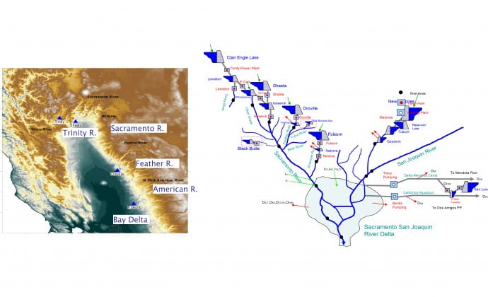

The Northern California River and Reservoir System
The northern California river system encompasses five major rivers (Trinity, Sacramento, Feather, American, and San Joaquin), five major reservoirs (Trinity, Shasta, Oroville, Folsom, and New Melones), 11 medium to small reservoirs, 12 hydro power plants (of 2,140 MW total generation capacity), 30 water supply nodes and diversions (including the aqueducts to southern California), and the Sacramento-San Joaquin (Bay) Delta, which is the habitat of hundreds of aquatic terrestrial species. The Oroville-Thermalito complex comprises the State Water Project (SWP), while the rest of the system facilities are federal and comprise the Central Valley Project (CVP).
The Northern California River and Reservoir system provides two-thirds of the state’s drinking water, irrigates 7 million acres of the world’s most productive farmland, and is home to hundreds of species of fish, birds, and plants. In addition, the system protects Sacramento and other major cities from flood disasters and contributes significantly to the production of hydroelectric energy. The Sacramento-San Joaquin Delta provides a unique environment and is California’s most important fishery habitat. Water from the Delta is pumped and transported through canals and aqueducts south and west and supports a multitude of vital water uses.
An agreement between the US Department of the Interior, Bureau of Reclamation, and the California Department of Water Resources (1986) provides for the coordinated operation of the SWP and CVP facilities (Agreement of Coordinated Operation-COA). The agreement aims to ensure that each project obtains its share of water from the Delta and protects other beneficial uses in the Delta and the Sacramento Valley. The coordination is structured around the necessity to meet the in-basin use requirements in the Sacramento Valley and the Delta, including Delta outflow and water quality requirements. Under normal hydrological conditions, the inflows from the Sacramento River, San Joaquin River, and the local stream flows can meet the needs of Delta demands and the water export. However, during dry water years, extra water has to be released from the upper major reservoirs to meet the demands. The COA specifies the manner in which the required extra water is shared by the large reservoirs in the Sacramento River basin (Clair Engle Lake [Trinity], Shasta, Oroville, and Folsom).
Project Scope and Activities
The Integrated Forecast and Reservoir Management (INFORM) project aims to develop and demonstrate integrated operational methodologies of climate and hydrologic forecasting and reservoir management to support reliable water supply for municipal, industrial, and agricultural users; energy generation; flood protection; recreation; fisheries management; and environmental and ecosystem sustainability.
The INFORM modeling system includes the following components:
- Climate Forecasting: NCEP GFS generates ensemble predictions of precipitation and temperature downscaled through WRF [10 x 10 km2; 6-hourly; 16 days lead]; NCEP CFS generates ensemble predictions of precipitation and temperature downscaled through ICRM [10×10 km2; 6-hourly; 41 days lead] and through probabilistic downscaling [10×10 km2; 6-hourly; 9 months lead]. [NCEP:National Center for Environmental Prediction; GFS: Global Forecast System; CFS: Climate Forecast System; ICRM: Intermediate Complexity Regional Model]
- Hydrologic Forecasting: CNRFC Snow Accumulation/Ablation and Soil Moisture Model; Hydrologic model uses the climate predictions and generates ensemble inflow forecasts [6-hourly–41 days lead; and daily–9 month lead].[CNRFC: California-Nevada River Forecast Center]
- River Routing; Water Quality Model; Bay Model: Nonlinear hydrologic river routing with data-derived parametric functions [6-hourly]; SRWQM river and lake water temperature model [monthly]; Statistical simulation of bay saline interface location [weekly]. [SRWQM: Sacramento River Water Quality Model]
- Reservoir and Hydropower Management: Hierarchical, multi-reservoir management model with full consideration of system uncertainties (INFORM DSS); Management model uses ensembles of inflow predictions and generates (a) ensemble predictions of system outputs [e.g., lake levels, river flows, energy generation, water temperature, salinity, etc.] and (b) probabilistic tradeoffs corresponding to alternative efficient management policies.
Annual Water Resources Outlooks
Related Publications
1. HRC-GWRI. 2006. Integrated Forecast and Reservoir Management (INFORM) for Northern California: System Development and Initial Demonstration. California Energy Commission, PIER Energy-Related Environmental Research. CEC-500-2006-109. http://www.energy.ca.gov/pier/project_reports/CEC- 500-2006-109.html]
2. HRC-GWRI. 2013. Integrated Forecast and Reservoir Management (INFORM): Enhancements and Demonstration Results for Northern California (2008-2012). California Energy Commission. Publication number: CEC-500-2014-019.
http://www.energy.ca.gov/2014publications/CEC-500-2014-019/CEC-500-2014-019.pdf
3. Georgakakos, K.P., Graham, N.H., Cheng, F.-Y., Spencer, C., Shamir, E., Georgakakos, A.P., Yao, H., and Kistenmacher, M., “Value of Adaptive Water Resources Management in Northern California under Climatic Variability and Change: Dynamic Hydroclimatology,” J. Hydrology, Vol. 412-413, pages 47-65, 2012. Also, on line reference doi:10.1016/j.jhydrol.2011.04.032, 2011.
4. Georgakakos, A.P., Yao, H., Kistenmacher, M., Georgakakos, K.P., Graham, N.H., Cheng, F.-Y., Spencer, C., Shamir, E., “Value of Adaptive Water Resources Management in Northern California under Climatic Variability and Change: Reservoir Management,” J. Hydrology, Vol. 412-413, pages 34-46, 2012. Also, on line reference doi:10.1016/j.jhydrol.2011.04.038, 2011.
5. Kim, D., and A.P. Georgakakos, “A New Nonlinear Hydrologic River Routing Model,” Water Resources Research, in review, 2014.
6. Kistenmacher, M., and A.P. Georgakakos, “Uncertainty Management for Multi-objective and Multi-dimensional Reservoir Systems, Water Resources Research, in review, 2014.
Acknowledgements
The INFORM project has been funded by the California Energy Commission, the National Oceanic and Atmospheric Administration (NOAA) and CALFED (a consortium of California and federal agencies). The project has been carried out jointly by the Hydrologic Research Center (HRC; California) and the Georgia Water Resources Institute (GWRI; Georgia) in collaboration with the California – Nevada River Forecast Center of the U.S. National Weather Service, U.S. Bureau of Reclamation, California Department of Water Resources, and California Energy Commission.
Additional information on the project activities can be found at http://www.hrc-lab.org/projects/dsp_projectSubPage.php?subpage=inform.