A Cold Front Brings Precipitation to the Midwest (author: Laurel Freeman)

The forecast for Tuesday, October 19 at 2 PM EDT (18 UTC Tuesday) to Wednesday, October 20 at 8 PM EDT (00 UTC Thursday) included a dry line from Kansas to southern Texas, a cold front from Kansas down to western New Mexico, and precipitation from Wyoming and Colorado to Eastern Michigan and Wisconsin. Figure 1 shows a progression of the surface data, which is exactly that: data taken at the surface. Surface data can include cold and warm fronts, precipitation maps, high- and low-pressure systems, as well as dry line symbols.

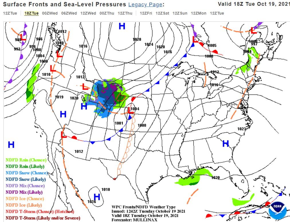
Figure 1: These are forecasted surface data maps from 18 UTC (2 PM EDT) Tuesday, 00 UTC (8 PM EDT Tuesday) Wednesday, and 00 UTC (8 PM EDT Wednesday) Thursday respectively. They show where rain is likely in green shades, high- and low-pressure systems, cold fronts, warm fronts, and dry lines. The main focus of these maps is the low-pressure system that propagates from Nebraska and Kansas eastward into Minnesota and Iowa by the last panel. (https://www.wpc.ncep.noaa.gov/#page=frt )


A cold front occurs when a mass of air that is cooler than the air it is moving towards advances and enters a warmer region. Cold air advection, or CAA for short, happens when colder air is pulled into a region. Through CAA, the cold side of the cold front became cooler and strengthened the front attached to the low-pressure system. (See Figure 2 for a map of CAA progression). The cold front created precipitation as it propagated Eastward by forcing warm, moist air upward, and this can again be seen in Figure 1 under the green shading.

Figure 2: These are forecasted cold air advection (CAA) and warm air advection (WAA) maps from 18 UTC (2 PM EDT) Tuesday and 00 UTC (8 PM EDT Tuesday) Wednesday. The blue represents CAA, the red represents WAA, and the green lines show where fronts are likely strengthening in a process called frontogenesis. (https://www.pivotalweather.com/model.php?p=700tadv&rh=2021102612&fh=loop&dpdt=&mc=)


A dry line occurs when warm air advection (WAA), which is like CAA but with warm air, occurs to the east of a section of drier air. In this case, warm, moist air was forecasted to be advected from the Gulf of Mexico into East Texas. A drier section of air was set up over the Four Corners region of the U.S., and a drastic moisture gradient can be seen in Figure 3. The green, blue, and purple shades indicate higher dew points, and the closer the dew point is to the actual temperature, the moister the air is. The gray and cream colors show low dew points that indicate dry air. Dry lines are capable of sparking severe weather as they force moist air upward and create rain and storms.

Figure 3: These are forecasted dew point maps from 18 UTC (2 PM EDT) Tuesday, 00 UTC (8 PM EDT Tuesday) Wednesday, and 00 UTC (8 PM EDT Wednesday) Thursday respectively. The greens, blues, and purples indicate higher dew points and therefore more moist air. The dryline combines with the cold front to drop dew points all the way from Mexico to Missouri into Iowa by 00 UTC Thursday. (https://www.pivotalweather.com/model.php?p=850td&fh=loop&dpdt=&mc=)


The key difference between a cold or warm front and a dry line is while both temperature and dew points can change drastically with cold or warm fronts, dry lines change the amount of moisture in the air. (It is possible that the temperature increases slightly on the dry side of a dry line. This is because dry air is easier to heat that moist air. The moisture gradient in a dry line is the main thing that changes after it passes though).


Southern Plains Severe Weather (author: Thomas Silas)

On the night of October 12, 2021, a severe weather outbreak occurred across portions of the southern Great Plains. Several reports of tornadoes, large hail, and damaging winds were collected by the Storm Prediction Center over the course of that day, primarily over southern Kansas and the panhandles of Oklahoma and Texas. A map of these storm reports can be seen below, along with the SPC’s convective outlook from that afternoon which featured a rare Moderate Risk area:

Figure 1: SPC 20Z convective outlook and storm reports from 12 October 2021.


On the afternoon of October 12th, a surface low pressure system was centered over eastern Colorado, with associated warm and cold fronts extending to the east and southwest respectively. However, the more noteworthy feature with respect to this event was the dryline analyzed extending south across western Texas almost all the way to Mexico. Drylines separate regions of moist air from regions of dry air. This can be seen in the dewpoint data from the surface observations in Figure 2: dewpoints range from 30s-40s west of the dryline to 50s-60s east of it. A wind shift is also visible at the dryline: winds east of the dryline are coming from the south to southeast, while they are out of the southwest on the west side. This makes sense, as a southeast wind would bring in moist air from the Gulf of Mexico, while a southwest wind would bring in dry air from the deserts of Mexico and the southwestern US. However, despite the dewpoint change and wind shift, there is not usually much of a temperature change across a dryline, and in this case temperatures are in the 80s on both sides. In fact, temperatures on the west side of the dryline are generally a couple degrees warmer than on the east side. This is because dry air has a lower heat capacity than moist air, so with daytime heating the western, dry side will typically heat up slightly more than the eastern, moist side. The surface map below from the afternoon of October 12th shows the dryline as an orange line with open semicircles on the moist side:

Figure 2: WPC surface analysis, 21Z 12 October 2021.


However, even east of the surface dryline, the effects can continue through what is known as an elevated mixed layer, or EML. These initially form as surface layers in the dry air over the higher terrain of the western United States and Mexico. However, when they are advected eastward towards the central plains, they maintain their original higher elevation and become elevated above moist air moving northward from the Gulf of Mexico. EMLs can be identified on a skew-T plot as layers above the surface where potential temperature is constant (temperature line parallel to dry adiabats) and mixing ratio is constant (dewpoint line parallel to lines of constant mixing ratio). An EML can be seen in the sounding from 00Z October 13 (Fig. 3) in roughly the 800 to 600 mb layer. This is a loaded gun sounding – if rising air parcels can break through the cap, strong thunderstorms are likely.

Figure 3: 00Z 13 October 2020 sounding from Dodge City, KS (KDDC) with skew-t (left) and hodograph (top right) plots.


That sounding also shows the significant amount of wind shear present, another factor important for strong thunderstorms and tornadoes. Near the surface, winds are out of the southeast, but then quickly shift with height to southwesterly. In addition, wind speeds are almost continuously increasing with height. The hodograph (diagram at top right of Fig. 3) shows this wind profile, with strong directional shear at low levels and speed shear throughout. This type of wind shear environment is favorable for severe weather such as supercells, squall lines, and tornadoes. Ultimately, multiple severe thunderstorms occurred in this highly unstable airmass. A couple individual supercells developed in western Oklahoma early in the evening due to a low-level jet, spawning a couple tornadoes, but most of the severe reports that day were from a squall line that initially formed in the late afternoon over eastern Colorado and New Mexico. This line tracked east through Kansas, Oklahoma, and northern Texas through the night, producing several tornadoes and reports of wind damage. Figure 4 below shows radar imagery of the two Oklahoma supercells and the developing squall line over western Kansas and the Oklahoma panhandle.

Figure 4: NEXRAD radar reflectivity, 0125Z 13 October 2021. (Source: UCAR Archive)

Another Weekend, Another Severe Weather Threat (author: Dorien Minor)

Although it seems like the synoptic patterns have remained busy through April so far, this has not necessarily translated to the number of severe weather and tornado reports that we except for this time of year. In fact, through 15 April 2021, data from the Storm Prediction Center (SPC) there have only been 34 tornado reports across the continental United States (Figure 1), which is much lower than the average number of April tornadoes: 155. This weekend has the potential to bring the April 2021 numbers closer to average, as a fast-moving synoptic feature will bring severe weather to the Southern Plains and the Southeast on Friday and Saturday. In fact, the categorial convective outlook from the SPC has a day 1 enhanced risk (level 3 of 5) over the Southern Plains at 20Z 23 April 2021, while another enhanced risk is centered over southern Alabama and Georgia. According to the SPC, the severe threats will be multifaceted, with the possibility of large hail, damaging wind and tornadoes.


Figure 1: Preliminary tornado reports from 1-15 April 2021 (red dots). Source: Storm Prediction Center (SPC) Monthly Severe Weather Report Database


Figure 2: NOAA/NWS Storm Prediction Center (SPC) categorial outlooks issued on 23 April 2021 for a) Day 1, 20Z 23 April 2021 to 12Z 24 April 2021, and b) Day 2, 12Z 24 April 2021 to 12Z 25 April 2021. Source: NOAA/NWS SPC Convective Outlooks.


As of 21Z 23 April 2021, the broader area of low pressure in charge of this round of severe weather is situated over the Texas Panhandle with a minimum mean sea level pressure of 998 mb. A shortwave trough, or one that is smaller and faster-moving than a typical longwave trough, exists just to the west of the surface lows along the border of Texas and New Mexico. Like many of the systems that have moved across the United States this month, troughs have played a huge role in the strengthening and/or maintenance of the surface low as long as the center of circulation is to the east of the trough axis. Fortunately for this surface low, it is! Regions to the east of the trough axis will have positive vorticity (cyclonic motion) advected into its vicinity as a result of a vorticity maximum being located in the base of the trough, which will cause the air above the low to rise. At 500 mb (Figure 3), this can be observed through lower values of vorticity over the surface low (apart from thunderstorms along the dry line), and higher values of vorticity within the base of the trough. Near the surface, vorticity advection is often weaker than the 500 mb level since there are weaker winds at the center of the surface low, which indicates that there is also positive vorticity advection increases with height, thus allowing for cyclonic motions to occur. This process occurs through Saturday and Sunday morning (24-25 April 2021) as well, as the low pressure center remains to the east of the shortwave trough axis throughout its journey from the Texas Panhandle to east of the Delmarva Peninsula.


Figure 3: Loop of the NAM forecasted 500 mb relative vorticity (fill, bottom scale) and 500 mb height (black contours) over the Continental United States from 18Z 23 April 2021 to 18Z 25 April 2021 using three-hour intervals. Source: Pivotal Weather


There’s a little bit of a problem, however, even though the low pressure center is in an environment that would be conducive for the continual strengthening of the cyclone over this period. At 700 mb, the distribution of temperature advection in the vicinity of the surface low often counteracts the rising motions described by differential vorticity advection. Figure 4 shows geostrophic temperature advection along the 700 mb pressure level, where warm air advection is shown in red. If we apply the fact that warmer air is less dense than colder air, then the movement of warmer air into regions of colder air promote the lifting of air parcels. Since rising motions are expected in regions of warm air advection, low pressure centers at the surface will tend to move towards these regions, which partially explains the eastward progression of the low. As the forecast period begins at 18Z 23 April 2021, the low pressure center in the Texas Panhandle is situated between weaker areas of cold air advection to its west and warm air advection to its east. Shortly thereafter, the regions of cold and warm air advection become less evenly distributed around the low pressure center because of precluding thunderstorms, which can cause localized or regional cooling effects prior to the arrival of the surface low. Because of this, the low pressure center occasionally becomes embedded in regions of cold air advection between 0Z 24 April 2021 and 12Z 24 April 2021, which promotes sinking motions above the low. When combined with the rising motion expected from differential vorticity advection, these processes nearly cancel each other out, and allows for the surface cyclone to maintain its strength (998-1003 mb) through 12Z 25 April 2021.

Please note that this post is a forecast for 23-25 April 2021, and conditions can change. In the event of inclement weather, ensure that you have multiple ways to receive weather warnings and have a plan of action before the storm arrives.


Figure 4: Loop of the NAM forecasted 700 mb horizontal temperature advection (fill, bottom scale), 700 mb temperature (black contours, in degrees Celsius) and 700 mb horizontal frontogenesis (green contours) over the Continental United States from 18Z 23 April 2021 to 18Z 25 April 2021 using three-hour intervals. Source: Pivotal Weather

Extratropical Cyclone Brings Rain and Severe Weather Across the US (author: Matt Salamoni)

It is clearly spring in the United States as another round of severe weather affected a large portion of the Midwest and Southern US. The catalyst for this round of severe weather was an extratropical cyclone making its way easy across the country (Figure 1). This system displayed classic extratropical cyclonic features as a cold front extended from the center of low pressure over the Iowa/Missouri border south to Louisiana and Texas and a stationary front extended west/northwest from the center of the low. (Figure 1). The main lifting mechanism that led to this convective activity was the cold front. While certain factors regarding the mesoscale may have had a greater effect on tornado development and localized severe weather, this blog entry will focus primarily on the synoptic scale environment and how it strengthened this extratropical cyclone.


Figure 1: WPC Surface Analysis map from 00Z 08 April 2021. Image courtesy of the WPC.


Identifying troughs and ridges at the 300 mb level along with jet streaks can provide valuable information regarding vertical motions in the mid-troposphere. Around 12Z 07 April 2021, a trough was present over Kansas and extended south into Texas. The surface low was located downstream of the trough and upstream of the ridge feature to the east (Figure 2A). Ageostrophic divergence was occurring aloft in this region which induced mid-tropospheric upward vertical motions via mass continuity. These upward vertical motions helped strengthen and maintain the surface low. There was a jet streak feature located over the 4 corners region of the US, but the upward vertical motions associated with the left jet exit region were a bit too far away to have an impact on the surface low. Moving forward in time to 18Z 07 April 2021, the trough has now propagated slightly further east. As a result, the upward vertical motions from ageostrophic divergence were still present downstream from the trough. However, the jet streak that was present was now positioned further east at this time (Figure 2B). Due to this, the ageostrophic divergence aloft in the left jet exit region led to upward vertical motions and strengthened the surface low. Evidence of this strengthening was seen as the central pressure of the system was 1002 mb at 12Z 07 April 2021 and it dropped to 998 mb around 00Z 08 April 2021.


Figure 2A (left) displays 300 mb height (black contours, mb), wind speed (fill pattern, knots), and divergence (contours, purple) from 12Z 07 April 2021. Figure 2B (right) displays 300 mb height (black contours, mb), wind speed (fill pattern, knots), and divergence (contours, purple) from 18Z 07 April 2021. The center of the surface low is labeled as a red “L”.


The tropopause can also provide valuable information on vertical motions in the atmosphere. Taking a look at potential vorticity can provide a view of what the tropopause looked like. A positive PV anomaly was present over the surface cyclone (Figure 3A). This indicates the height of the tropopause was lower over this region. Cross sectional data of this anomaly will allow for the analysis of vertical motions in the mid-troposphere. The cross-sectional data clearly depicts a positive PV anomaly, as the stratosphere dips down into the troposphere which lowers the tropopause height (Figure 3B). A positive PV anomaly is a max in vorticity, and due to the thermal wind flowing to the east, it advected higher values of vorticity east of the anomaly. As a result, upward vertical motions occurred east of this anomaly, and strengthened the surface low.


Figure 3A (left) displays PVU Pressure (hPa, fill pattern), wind (barbs), and low-pressure centers. Figure 3B (right) displays a cross section of the +PV anomaly. Images courtesy of Tropical Tidbits.


Another way the cyclone strengthened was due to condensational heat release from precipitation along the cold frontal boundary (Figure 4). The precipitation along the cold front causes latent heat release. This diabatic heating maximum strengthened the positive PV anomaly at the surface and weakened it in the upper troposphere. This in turn raised the tropopause height through the creation of negative PV and this led to ridge building downstream of the trough. This enhanced the trough-ridge dynamics that were previously mentioned and strengthened the surface cyclone. Overall, the synoptic scale environment had a large impact on the strengthening of this extratropical cyclone.


Figure 4: Radar reflectivity data from 07 April 2021 at 23Z. The fill pattern (dBz) represents precipitation and its intensity.

Blog Post 2 (author: Thomas Silas)

The second week of April 2021 was the first time in quite a few weeks that a major severe weather outbreak was not expected to occur in the United States. Despite this, relatively active weather was still observed in several areas of the country. One such region was the Intermountain West, which was affected by a surface low-pressure system from Tuesday into Thursday. This cyclone initially formed in association with an upper-level positive potential vorticity (PV) anomaly. Potential vorticity is the product of absolute vorticity and static stability, and is measured in potential vorticity units (PVU). In general, PV is much higher in the stratosphere than in the troposphere, and the boundary between them is often defined as a 2 PVU surface. A region where higher PV values extend lower down in the atmosphere than surrounding areas (such as the one in the cross section below) is known as a positive PV anomaly. Through a somewhat complex cyclogenesis process, positive PV anomalies at the tropopause can cause a cyclonic circulation to form at the surface to the east, creating a surface low pressure center. This explains the formation of the surface low over Nevada on the 13th. The following image is a cross-section of this PV anomaly at 12Z 14 April: the fill pattern is PV (with a black dotted line marking the 2 PVU contour):


Figure 1: GFS cross section of a positive PV anomaly at 12Z 14 April 2021 showing PV, potential temperature, and wind contours. (Source: Tropical Tidbits).


The cross section also shows a wind maximum of over 100 knots just south of the PV anomaly. This is the location of the jet stream, which can also be seen on the 250 mb wind map below. The surface low is located to the east (downstream) of an upper-level 250 mb trough over Nevada and to the west (upstream) of a ridge over the central US. It is also in the left exit region of the jet streak over southern California. The surface low’s position relative to the trough, ridge, and jet streak is a favorable environment for ageostrophic divergence at upper levels due to both trough-ridge and jet streak dynamics. When air at upper levels diverges, air from below must rise to replace it. This upward vertical motion in turn can cause the development or strengthening of a surface low pressure system.


Figure 2: GFS 250 mb wind at 12Z 14 April 2021, with surface high and low pressure centers. (Source: Tropical Tidbits)


The low pressure system that developed in this area created an ideal synoptic environment for a downslope wind event to occur over parts of northern Utah west of the Wasatch Mountains on Tuesday night and early Wednesday morning. According to the National Weather Service in Salt Lake City, two main conditions are required for a downslope wind event: cold dense air against the east side of the mountains, and easterly winds to push this air over the mountain tops. When this happens, the air quickly sinks on the west side due to its higher density, and the highest speeds occur when it reaches the bases of the mountains. Analysis of surface observations taken at 06Z April 14 shows that both of these conditions were present:


Figure 3: Surface observations at 06Z 14 April 2021. (Source: Weather Prediction Center)


At that time, the surface low discussed above had a pressure of 996 mb and was centered over southern Nevada. High pressure was located over the Great Plains, creating a strong pressure gradient over northern Utah and southern Wyoming (note how close the isobars are to each other in this region). Air moves counterclockwise around low pressure and clockwise around high pressure, so this produced fairly strong easterly winds over northern Utah. In addition, temperatures east of the mountains were 20-30 degrees lower than to the west, and dewpoints were also 10-20 degrees lower. Since air is more dense when it is cold and dry, this meant density conditions were also favorable for a downslope wind event, and the local National Weather Service office issued a high wind warning as a result. Ultimately, multiple wind gusts over 50 mph were observed across the Salt Lake City, Ogden, and Logan metropolitan areas, with a peak gust of 84 mph recorded in South Weber, UT.


Figure 4: Peak wind gusts over 50 mph in northern Utah from the early morning of 14 April 2021. (Source: National Weather Service Salt Lake City, UT)

Multiple Disturbances in the Midwest (author: Brad Rubin)

Several disturbances in the mid-levels were present over the 48hr time period from 18z Thursday the 8th-18z Saturday the 10th that caused widespread showers and thunderstorms (including severe thunderstorms) across the Midwest and South. Both disturbances resulted from moderate to strong positive vorticity anomalies due to colder and more stable stratospheric air penetrating into the troposphere. This brings higher values of potential vorticity into the troposphere that can translate to regions of positive vorticity advection in the mid-levels and strengthening surface cyclones. Positive vorticity anomalies in addition to positive vorticity advection in the mid-levels and temperature advection at the lower levels (looking at QG-Theory) will lead to the formation of convection.

Fig. 1 below shows a 500hPa relative vorticity map from Alisha Bentley’s website at 00z Friday (~8PM EDT Thursday). A mid-level cyclone is present over the Midwest and the warm-color fill pattern indicates higher vorticity values. These values of higher vorticity are likely caused by a positive vorticity anomaly in the tropopause that’s translating to enhanced vorticity at the mid-levels. In order to deduce where any upward vertical motions are occurring we can


Figure 1: 00z Friday, April 9th 500hPa Relative Vorticity (Alisha Bentley)
Geopotential Heights (black contours every 60m)
Cyclonic, relative vorticity (red, orange, yellow fill pattern, 1/s)
Ascent (blue contours, hPa/s)


use QG theory to perform sign analysis on the QG-omega equation. Term A of QG-omega deals with positive differential vorticity advection by the geostrophic wind. What you’re looking for on the map for Fig. 1 is are higher values of vorticity being advected into regions of lower values of vorticity. Following geopotential height contours, we can see that the geostrophic wind is advecting higher values of vorticity from the mid-level cyclone eastward into the Midwest and parts of the South. This is where you can see the blue contours representing upward vertical motions occurring just downstream of the cyclone. I would expect a positive Term A in this scenario. If we move on Term B, this deals with whether warm air advection is present over


Figure 2: 00z Friday, April 9th 850mb Temp. Adv. (Meso. Analysis Archive)
Geopotential Heights (black contours every 30m)
Temp. Advection (fill pattern)
Wind barbs (knots)


a region. Fig. 2 shows 850mb temperature advection at 00z Friday and the red colors indicate areas of warm air advection. You can see this is occurring over the same region as the positive vorticity advection and while not very strong, this will still result in a positive Term B. This makes righthand side of the QG-omega equation positive, implying a positive left-hand side as well. This indicates a minimized omega term which implies upward vertical motions and possible convection.

Taking a look at the second disturbance that made its way across the same region Friday night and Saturday, Fig. 3 shows the same relative vorticity map from Alisha Bentley’s website but at 12z Saturday (8AM EDT). Again, there is noticeable high values of relative vorticity being advected into regions of lower values of relative vorticity and resulting rising motions so if


Figure 3: 12z Saturday, April 10th 500hPa Relative Vorticity (Alisha Bentley)
Geopotential Heights (black contours every 60m)
Cyclonic, relative vorticity (red, orange, yellow fill pattern, 1/s)
Ascent (blue contours, hPa/s)


looking at the QG-omega equation and Term A again, a positive term is expected. One thing that is different with the second disturbance however is a more well-defined vorticity anomaly present over the Midwest. Fig. 4 is a 2PVU surface map from Pivotal Weather. PVU stands


Figure 4: 12z Saturday, April 10th 2PVU Surface Theta Map (Pivotal Weather
Theta (color fill pattern, Kelvin)
Wind barbs (knots)


for “positive vorticity unit” and is a way to quantify vorticity in the troposphere and stratosphere. Specifically, 2 PVU is representative of the tropopause, separating higher PVU air in the stratosphere above and lower values of PVU in the troposphere below. This map specifically uses values of theta (fill pattern) to indicate where higher and lower values of PVU are because regions of higher vorticity have lower air columns which means colder temperatures relative to the surrounding air columns and vice-versa with regions of lower vorticity. While this doesn’t point out anomalies, it gives an idea of where higher and lower values of vorticity may be. There is a well-defined region of lower theta values (meaning higher PVU air) right where the mid-level cyclone is located. Mid-latitude cyclones are what are known as cold core systems meaning the air right below them is colder relative to the surrounding air. This is due to positive vorticity anomalies that are resulting in positive vorticity advection occurring at the mid-levels as depicted by Fig. 3.

Getting back to QG theory, we already determined a positive Term A but now let’s look at Term B again and see if any warm air advection is occurring in the region of the cyclone.


Figure 5: 12z Saturday, April 10th 850mb Height, Wind, Temperature (Pivotal Weather)
Geopotential Heights (black contours every 30m)
Temperature (color fill pattern, Celsius)
Wind barbs (knots)


Fig. 5 shows 850mb temperatures from Pivotal Weather. Using the wind barbs provided with this map you can see where any warm air is heading towards. South/Southwesterly winds are accompanying warmer temperatures at 850mb from the Gulf Coast up into the Midwest and South. This hints at a positive Term B within the QG-omega equation which implies an overall positive left-hand side. This implies a positive righthand side and minimized omega, thus resulting in upward vertical motions. Not only are upward vertical motions present over the Midwest and South but upper-level vorticity anomalies can translate down to the mid-levels (as shown earlier with the Alisha Bentley maps) and to the lower-levels by strengthening surface cyclones. A sub-1000mb low did indeed form over East Texas and moved east towards the Southeast which made the overall storm event more potent.

Blog Post – April 1, 2021 (author: Jordan Murdock)

In the southeast region, March 31st ended up being a day to stay inside as a low-pressure system moved through Mississippi, Alabama and eventually through Georgia explaining the storms that Atlanta experienced during the mid-afternoon. Moving into April 1st, the squall line moved east of Atlanta as some storms were still being experienced around 0Z but by 12Z April 1st, the precipitation had moved off the coast of the Carolinas, shown in Figure 1. April 1st, although a sunnier day for the southeast, brought severe weather in the northeast region with a low-pressure system moving through until it moved off the coast of Rhode Island by 12Z. This system brought snow (shown in blue) on the backside of the storm to Pennsylvania and New York with the addition of some lake effect snow in the trough moving through Ohio and Illinois.


Figure 1: Surface map showing pressure contours and precipitation type at 18Z March 31st (top left), 00Z April 1st (top right) and 12Z April 1st (bottom) to show how the low-pressure system moves east of the southeast region and the trough settles over the southeast before also moving east of it.


After the squall line moved through the southeast region, behind it came a cold front that stretched down through Louisiana and eventually connected with the low-pressure system in the northeast bringing cooler temperatures to not only the southeast but the Carolinas, Virginia and the northeastern states as well. Looking at Figure 2, the cold front moved through the southeast region from 0Z March 31st to 06Z April 1st and eventually led to the colder temperatures observed at 12Z April 1st. Figure 2 (top left) and figure 2 (top right) show the cooler drier air behind the cold front in Alabama that moves over the warmer moister air that is ahead of the cold front. There is also a change in the wind direction and speed between in front of the cold front and behind it.


Figure 2: Surface analysis map showing the different temperatures, dew points and wind speed across the United States. The different fronts can also be seen, specifically the cold front moving across the southeastern U.S. from 18Z Wed Mar 31 (top left) to 12Z Thur Apr 1 (bottom right).


Moving into the upper levels, the 250 mb map (figure 3) shows the jet streak present across the United States with strong wind speeds due to the temperature gradient with the cold front. The jet streak implies there is strong vertical wind shear. Looking at figure 3, the subtropical jet streak in the Texas gulf area, connects into the jet streak throughout the Midwest area. This helped guide the squall line indirectly east. Also, looking at the right jet entrance region, due to the squall line being present in that area, it was impacted by synoptic scale lifting. Lastly, looking between the large ridge over the western U.S. and the deep trough over the eastern U.S., there is a high-pressure system observed over Nebraska which shows a textbook subsidence region from upper-level dynamics and this is what is impacted the southeast region on April 1st and into the coming hours. The 500 mb vorticity map (figure 4), showing the rotation of flow in the atmosphere, shows the trough feature moving east of Atlanta taking the vorticity maximum along with it. This is what is brining these clear skies since there will be no precipitation due to this as Atlanta sits at the base of the trough currently and eventually will be east of it bringing negative vorticity advection over Atlanta and in turn downward vertical motion being experienced.


Figure 3: 250 mb map from 03Z April 1st, showing the jet streak throughout the entire United States, specifically noting on the subtropical jet over Texas and the gulf and the stronger winds coming off of the trough into the northeast region.


Figure 4: 500 mb relative vorticity map from 12Z April 1st showing the trough present and the vorticity max moving east of the trough and Atlanta


Focusing lastly on the downward vertical motion that will exist over Atlanta as stated previously, the 850 mb temperature advection map (figure 5, left) shows the cold air passing through and the downward vertical motion or subsidence that will be present. In figure 5, in the blue fill patterns on the backside of the cold front due to the strong temperature gradient experience downward vertical motion. This can be confirmed by looking at figure 5 (right), the 850 mb vertical velocity map where the gray areas show downward vertical motion which maximizes cold air advection. There is a line from Louisiana through Mississippi through Alabama, where there is negative values of vertical velocity shown by the gray areas. This lines up with cold air advection being maximized. Downward vertical motion is also exhibited in association with the cold frontal passage. In turn, this explains the lack of clouds in the sky as cold air advection was still being experienced throughout the entire day.


Figure 5: (Left) 850 mb temperature advection map showing the cold air passing through and the downward vertical motion or subsidence that will be present. (Right) 850 mb vertical velocity map showing in gray downward vertical motion which maximizes cold air advection or upward vertical motion in red

Synoptic Blog Post #2 (author: Laurel Freeman)

The first week of April saw an interesting event bring about the potential for precipitation over Northern California and Oregon. This feature looked to be an upper-level cutoff feature, which indicates a geopotential height minimum. While upper-level cutoff features do not always lead to precipitation, there were several reasons to indicate this one might. The 300 mb wind map in Figure 1, for example, showed a small jet streak to the south of the upper-level cutoff on Monday 2021 April 05 at 12 UTC. The left jet exit region causes divergence aloft, which induces upward vertical motion and systems to strengthen. The height contours show the cutoff feature over Oregon and Washington. This is an example of how upper-level features do not always align with lower level features can still be related.


Fig. 1: A wind map at 300 mb with height contours (in dam) in black, and the fill pattern is the wind (in kts) forecasted for 12 UTC on 2021 April 05. The main feature to focus on is the cutoff feature moving eastward over Washington and Oregon (source: https://www.pivotalweather.com/model.php?m=gfs&p=300wh&rh=2021040518&fh=0&r=conus&dpdt=&mc=)


The 500 mb vorticity map in Figure 2 shows relative vorticity and rising motion. Looking between the 850 mb wind vs the 500 mb wind in Figure 3, the vorticity on the Figure 2 map seems to be shear vorticity. Shear vorticity is caused when air is moving at different speeds at different levels of the atmosphere, and if the shear vorticity is cyclonic shear vorticity, upward vertical motion is likely to occur downstream. Figure 2 confirms this. The movement of the vorticity into an area, called positive vorticity advection, can lead to strengthening of systems as a result of this upward motion.


Figure 2: ) A map of 500 mb relative vorticity (shaded using the scale listed),wind barbs in knots, 500 mb geopotential height contours in black, and ascent in blue forecasted for 12 UTC on 2021 April 05. (source: http://www.atmos.albany.edu/student/abentley/realtime/standard.php?domain=northamer&variable=rel_vort)


Figure 3: (left panel) This is a map of 500 mb wind (shaded using the same fill pattern as in Fig. 1), and height contours in black in dam forecasted for 12 UTC on 2021 April 05 (source: https://www.pivotalweather.com/model.php?rh=2021040518&fh=0&dpdt=&mc=&r=na&p=500wh&m=gfs), and (right panel) is a map of 850 mb wind with the same fill pattern as Fig. 1 and height contour in black in dam forecasted for 2021 April 05. A side note: the gray area on the 850 mb map is there because the terrain rises higher than 850 mb. This is normal for some parts of the western U.S. at higher elevations. (source: https://www.pivotalweather.com/model.php?m=gfs&p=850wh_nb&rh=2021040518&fh=0&r=na&dpdt=&mc=).


Looking at the height of the tropopause (the layer of the atmosphere where most weather takes place), temperature advection, and predicted surface precipitation, this specific system looked to be a cold core low when coupled with all the other elements. Figure 4 is a gif of these maps respectively. Cold core cyclones are stronger aloft due to thermal wind, which is a change in geostrophic wind between pressure levels. Lower thickness contours are to the left of the thermal wind vector in the Northern hemisphere, and these lower thickness contours tend to correspond with lower temperatures. With the cooler air at the center of the cyclone and temperature decreasing with height, the thermal wind gets stronger the higher up in the troposphere. This can lead to precipitation. The 700 mb temperature advection map and low tropopause height on the 2 PVU map in Figure 4 both show cold air moving into the region where the low is at the surface approximately (lower (higher) tropopause heights usually indicate cooler (warmer) air).


Figure 4: This gif has three images: the PVU 2 (potential vorticity unit) map is used to estimate the height of the tropopause, and it is coded using the fill pattern on that slide and has wind barbs as well to indicate wind speed. (source: https://www.tropicaltidbits.com/analysis/models/?model=gfs&region=us&pkg=DTpres&runtime=2021040518&fh=6). The 700 mb temperature advection map had the fill pattern showing the change in temperature in K/hr, the blue contours are an estimate of cold air advection, and the red contours are an estimate of warm air advection. (source: https://www.tropicaltidbits.com/analysis/models/?model=gfs&region=us&pkg=temp_adv_fgen_700&runtime=2021040518&fh=6). The surface map has sea level pressure contours (hPa) in black, thickness contours in red and blue (dam), and precipitation following the fill pattern. High pressure systems are the blue letter “H” and low pressure systems are the red letter “L”. (source: https://www.pivotalweather.com/model.php?m=gfs&p=prateptype_cat&rh=2021040518&fh=0&r=na&dpdt=&mc=)

Blog Post – Synoptic Meteorology – Observations (author: Sydney Hopkins)

On March 25, the development of a system capable of severe weather can be seen over the southeast portion of the US. In Figure 1, showing an IR satellite image of the US on March 15 00Z, you can see some cold temperatures associated with this system particularly over parts of Alabama and Mississippi, as well as northeast Texas. Clouds over northeast Texas appear to be registering the coldest temperatures in the area. These cold temperatures imply clouds reaching higher into the atmosphere, which suggests conductivity in the region. The associated radar image from this time shows high radar reflectivity over Texas and the southeast, indicating high levels of precipitation in the area (Figure 2). The radar loop of the previous 48 hours shows the system centered over Mississippi and Alabama has strengthened somewhat. A surface analysis taken at this time can be seen in Figure 3. The plot shows surface lows forming over Texas associated with a warm front that extends south from a low pressure system centered over northern Wisconsin. The plot also shows cloud coverage forming in the southeast.

Figure 1: IR Satellite image with color showing coldest temperatures


Figure 2: Radar Image of US, March 15 00Z


Figure 3: Surface Analysis, March 25 00Z


The system producing heavy precipitation over Mississippi and Alabama is positioned in the left exit region of the jet stream, as seen below on the image showing 1000-500 hPa thickness and 250 hPa wind speeds (Figure 4). This, along with this system being positioned in an upstream ridged/downstream trough region, should create the right conditions for this system to continue strengthening as it moves further into the southeast. This is a result of these regions favoring ageostrophic divergence and upward vertical motions, which are favorable to the development of cyclones.

Figure 4: 1000-500 hPa thickness, 250 hPa wind speed, March 25 00Z


The cyclone associated with the surface low moving into the southeast should also continue to strengthen as a result of the cyclone helping transport warm, moist air from the Gulf of Mexico into the region. In Figure 5, an image showing precipitable water shows high levels of precipitable water, or moisture over the Gulf of Mexico moving into the southeast. This should also lead to mid-tropospheric upward vertical motions as a result of the warm air advection. In figure 6, high levels of CAPE can be observed in the region over the gulf of Mexico, indicating stronger weather and thunderstorms.

Figure 5: 700 hPa heights, temperature, wind, precipitable water, March 25 00Z


Figure 6: 850 hPa heights, temp, CAPE, 1000-500 hPa shear, March 25 00Z

March Severe Weather Continues (author: Matt Salamoni)

Continuing the trend of this March, another severe weather outbreak affected the Southeastern United States primarily on March 25th. On this day, there were 42 reports of tornadoes and 51 hail reports (Figure 1). One of these tornadoes reached EF-4 strength in Newnan, GA. A low-pressure system with a central pressure of 1004 mb was the reason for this convective activity. Centered over Arkansas around 11 AM on March 25th, this low was situated in a very favorable region for surface cyclone strengthening and maintenance. Analysis of the synoptic environment at this time can provide more information on why this low strengthened.

Figure 1: SPC Storm Report of the United States for 25 March 2021. This plot displays tornado reports (red), wind reports (blue), hail reports (green), and total reports (black). Image courtesy of the Storm Prediction Center.


The 300 mb level can provide valuable information about the synoptic environment by analyzing the jet stream. At 15Z (11 AM EDT) March 25, a deep trough is present over the Central/Western US extending from the Dakotas & Montana southward to New Mexico & Texas (Figure 2). With respect to the trough, the surface low is located in the region downstream (east of the trough). This region is associated with ageostrophic divergence aloft due to the orientation of the ageostrophic wind vectors. This divergence aloft will induce upward vertical motions in this region via mass continuity. These upward vertical motions will strengthen the surface low. Additionally, 2 jet streaks are present, a smaller one over east Texas and a larger one over the Midwest and Great Lakes Region (Figure 2). With respect to these jet streaks, the surface low is in the left-exit region and right entrance regions. Both of these regions are associated with upward vertical motions due to ageostrophic divergence aloft. As a result, both jet streaks will strengthen and maintain the surface low.

Figure 2: This plot displays 300 mb height (contours, black) , wind speed (fill pattern), and divergence (contours, purple). This plot is from 15Z 25 March 2021. Image courtesy of the SPC Mesoscale Analysis Archive.


Moving vertically downward in the atmosphere, vorticity at the 500 mb level and 700 mb level can be used to further assess vertical motions in the atmosphere. The reason this analysis is possible is due to the QG Omega Equation. Term A (the first term) of this equation is the vertical derivative of absolute geostrophic vorticity advection by the geostrophic wind. More simply put, this term analyzes rotation and how it is moving in the atmosphere. At the 500 mb level, positive vorticity is being advected into the region where the low is centered (Figure 3A). In addition, at the 700 mb level positive vorticity is also being advected into the region where the low is centered (Figure 3B). Increasing positive vorticity advection with height is indicative of mid-tropospheric upward vertical motions, and these motions will strengthen the surface low.

Figure 3: 2A (left) is a plot of 500 mb height (contours, black) and relative vorticity (fill pattern) from 15Z 25 March 2021. 2B (left) is a plot of 700 mb height (contours, black) and relative vorticity (fill pattern) from 15Z 25 March 2021. Images courtesy of Pivotal Weather.


Term B of the QG Omega equation is the Laplacian of geostrophic temperature advection. This a complicated way of saying this term looks at cold versus warm air advection and its role in atmospheric vertical motions. The counterclockwise flow associated with the surface low will advect warm, moist air from the Gulf into the region where the surface low is located (Figure 4). This warm air advection over this region is indicative of mid-tropospheric upward vertical motions due to the QG omega equation. Overall, this surface low was strengthened by upward vertical motions from a variety synoptic factors such as trough/ridge dynamics, jet streak dynamics, and QG Omega dynamics. The synoptic scale environment played a crucial role in strengthening this surface low, which allowed it to take full advantage of the primed mesoscale environment leading to another spring severe weather outbreak.

Figure 4: This plot displays 850 mb height (contours, black) and temperature (fill pattern) from 15Z 25 March 2021. Image courtesy of Pivotal Weather.