No Joke: April Begins With Alabama Tornado Outbreak (author: David Neal)

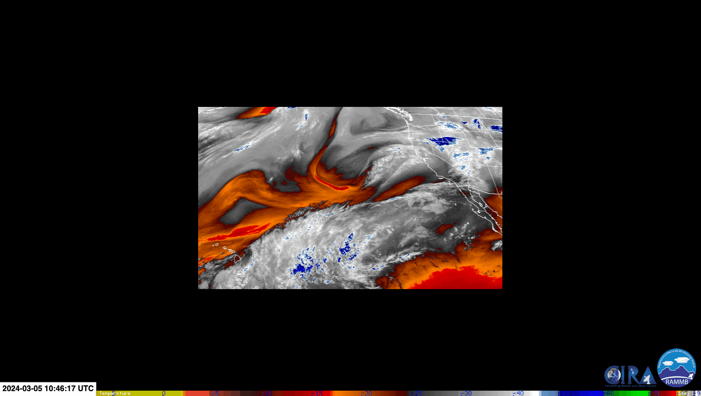
Monday, April 1 brought bright sun and temperatures into the 80’s for the southeast U.S., but don’t be fooled, this quiet weather soon turned deadly. On Tuesday night, dangerous thunderstorms produced multiple tornadoes across the state. Fortunately, minor damage was the worst of these low-strength tornadoes, but amidst a disorganized storm under the cover of night, how did meteorologists recognize these tornadoes and keep the public safe?

Figure 1. Storm Prediction Center (SPC) Storm Reports, April 2, 2024 (from https://www.spc.noaa.gov/climo/reports/240402_rpts_filtered.gif)

Not Your Average Thunderstorm

Thunderstorms began to flare up Tuesday night as a cold front pushed into the warm, moist air over Alabama, with the potential for tornadoes. National Weather Service-Birmingham meteorologist Nathan Owen forecasted “areas that will have the best chance for tornado development will be south of I-20 and north of I-85 between 6pm and midnight.” He was right. However, the thunderstorms were not typical supercell thunderstorms that produce tornadoes. Supercells have a signature characteristic of hook shaped precipitation on its southern edge, known as a hook echo, as seen in the circle in Figure 2.

This feature frequently indicates tornadic activity, making issuing a tornado warning somewhat easier for meteorologists to see on radar, as the hook protrudes out of the supercell.

However, Tuesday night’s storm, as seen in the red box (the Tornado Warning) in Figure 3, did not have the structure of a supercell thunderstorm, so a hook was not able to help meteorologists identify the evolving tornado. The tornado was also surrounded by moderate to heavy rain, adding to the difficulty of identifying it.

Figure 2. Reflectivity Factor radar during the supercell that produced the El Reno Tornado, 2013 (from https://storymaps.arcgis.com/stories/9895d535c2a247e4997fb85493428be8)

Figure 3. Reflectivity Factor radar during Tuesday night’s storm (from RadarScope™)

No Hook Echo? No Problem

When meteorologists can’t observe a tornado based off of rain patterns on a standard reflectivity factor radar, they can use a storm relative velocity radar to detect rotational motion.

As seen in Figure 4, this radar encompasses two colors: green, indicating wind directed towards the radar, and red, indicating wind directed away from it. Because a tornado is characterized by rotating winds, pockets of green intertwined with red, or vice-versa, make obvious to meteorologists of escalating rotating motion indicative of a tornado.

However, due to Tuesday’s tornado being less intense, these pockets were not as apparent, but miniscule sections of lighter green and pink adjacent to each other reflected localized higher wind speeds with mild rotation, as seen in the red box.

Figure 4. Storm Relative Velocity radar (from Radar Scope™)

Rain & Wind Aren’t The Only Things Radar Can Detect

A correlation coefficient (CC) radar can also be used to observe tornadic activity. Dark, dull colors reflect something in the atmosphere being differently shaped or sized than its surroundings. However, reds, pinks, and whites reflect whatever is in the atmosphere having similar sizes and shapes, like a storm having only rain.

A tornado can produce a noticeable debris ball, or a circle of debris. This debris ball can contain objects of many different shapes and sizes, as tornadoes can pick up cars, trees, and roofs to name a few. The CC radar recognizes this variety in the atmosphere, and the debris ball is then indicated by darker colors of blue, gray, or black if the debris ball is elaborate.

Within the red box (the Tornado Warning) in Figure 5, there exists orange and yellow, different from the more solid pink colors elsewhere. Although not as apparent as a dark debris ball associated with a severe tornado, this color differentiation on the CC radar indicates slightly different shaped and sized constituents in the atmosphere, essentially something other than rain in this thunderstorm.

This mild debris ball being located where the rotating winds on the storm relative velocity radar are allowed NWS-Birmingham meteorologists to recognize this tornado and issue a Tornado Warning, despite the difficulties of this storm’s nature.

Figure 5. Correlation Coefficient (CC) radar (from RadarScope™)

Storms Sweep Across the Southeast (author: Madeline Laesser)

On Friday, March 22nd, and going slightly into the weekend, the southeast received significant rain and severe weather in some regions. In figure 1, the imagery shows that there was significant cloud coverage over the southeast region on Friday, specifically Florida, Georgia, and South Carolina. Since this is IR imagery, the clouds are identified based on the heat that is radiating off of them which the satellite measures. The colder cloud tops are associated with more severe weather. The most severe weather happened in the gulf earlier in the day on Friday. The National Weather Service(NWS) offices in Tallahassee and Miami released “special marine warnings” in areas off the coast because of strong winds and possible water spouts. Many areas of the states where this cloud coverage is shown received thunderstorms with quite a bit of rain.

Fig. 1: Infrared(IR) satellite imagery GOES-16 valid at 06 UTC 22 March 2024 to 06 UTC 23 March 2024. Images are in increments of 30 minutes. The color bar is on the bottom in degrees Celsius. Black represents the warmer temperatures, and the blues and greens are colder colors. Note that the horizontal color bar goes from warmest on the left to coldest on the right.

Credit: Colorado State University CIRA RAMMB Slider Page

In figure 2, the radar imagery can give us insight on the intensity of the precipitation at the times shown. Notice that the cold cloud tops on the satellite imagery correspond to where the most intense precipitation is shown on the radar. The precipitation in Florida moved eastwards while precipitation also formed on the north coast of the gulf and had significant coverage over Georgia and South Carolina in the afternoon. The precipitation in Florida is a result of the upward vertical motion caused by the surface low pressure system. The precipitation over Georgia and South Carolina is the result of a shortwave trough in the mid-levels of the atmosphere. Georgia and South Carolina are to the east of the trough axis which is an optimal area for upward vertical motion. Upward vertical motion allows for clouds, precipitation, and more severe weather to form.

Fig. 2: This figure shows composite reflectivity radar images at three time frames. The leftmost image is at 1200 UTC 22 March 2024. The middle image is 1800 UTC 22 March 2024. The rightmost image is 0000 UTC 23 March 2024. The color bar is on the right of each image. The yellow and orange represent the most intense precipitation that can be seen in this image. The light blue is less intense.

Credit: NSSL Multi-Radar Multi-Sensor (MRMS) Operational Product Viewer

In figure 3, the surface analysis shows the low pressure systems that were in the gulf. The low pressure systems were in the regions discussed where the coldest cloud tops were and the most severe precipitation. There was a cold front that was in the southeast. This cold front brought in a dry air mass that is what caused the precipitation to stop on Saturday. The most severe weather this past Friday was in Florida where there were more risks of tornadoes and special marine warnings off the coast. That being said, Georgia received significant rain with many places receiving between 1-2 inches of rain. There were not concerns of floods concerning impacts in these regions like there were in Florida from the surface low pressure system.

Fig. 3: This figure is a surface analysis with fronts and analysis only of the United States valid at 1800 UTC 22 March 2024. The dark red contours represent surface pressure in millibars(mb) in intervals of 4 mb. The surface low pressure systems are denoted by a red L, and the surface high pressure systems are denoted by a red H. The dark red, underlined numbers are the surface pressure(in mb) of the low or high surface system it is near. Cold fronts are represented with blue lines with triangles pointing in the direction it is moving towards. Warm fronts are represented by red lines with semi-circles in the direction it is moving towards. Stationary fronts are represented by alternating cold front and red front symbols. Occluded fronts are represented by purple lines with alternating semi-circles and triangles.

Credit: WPC Surface Analysis Archive

Winter Weather In The Great Plains & Upper Midwest (author: Emily Melvin)

Between Sunday, March 24th, and Tuesday, March 26th a major winter storm impacted the Great Plains and upper Midwest region. Fueled by strong upper-level trough ridge dynamics, a 991 mb low formed over Kansas which not only influenced blizzard conditions to the north over the Dakotas and Minnesota, but also caused some severe weather in the southern great plains. An upper-level trough over the Rockies with an embedded jet streak (region of higher wind speeds) enhanced upward vertical motion over the central great plains. This upward vertical motion allowed the surface low-pressure system to strengthen and continue to support precipitation impacts in both the warm sector to the southeast and the cold region to the north.

March 25 0006 Z GFS 300mb heights in dam (black contours) and winds in kt (barbs, and fill pattern), accessed from pivotalweather.com

March 25 0006 Z GFS Precipitation type and rate (green rain, blue snow, pink mixed precipitation), thickness in dam (red (above freezing) and blue (below freezing) dashed contours) and sea level pressure in hPa (black contours), accessed from pivotalweather.com

To the north of the storm, there was ample stratiform precipitation in the form of snow from Nebraska through Minnesota. The highest snow totals were found in Minnesota where the most widespread precipitation was found. There are signatures of this widespread precipitation in the IR cloud top satellite image provided below. The brighter green colors indicate higher and colder cloud tops, which is a sign of heavier precipitation. Despite there being less snow over Nebraska and South Dakota, those are the regions that experienced blizzard conditions. This is due to their closer proximity to the surface low-pressure system to the south. The closer a location is to the core of a midlatitude storm, the faster winds they will experience. For an area to be experiencing true blizzard conditions there must be three hours of blowing or falling snow, winds surpassing 35 mph, and sub quarter mile visibility.

Infrared Satellite Image Goes-16 Cloud Tops Band 11 Accessed from the CIRA RAMMB Slider

Key upper midwest impacts highlighting the snowfall, the winds, and the region of blizzard conditions in Nebraska and South Dakota. Accessed from NOAA Weather Prediction Center

To the south of the low-pressure system, there were some minor severe weather impacts. In particular, there was a series of EF-1 tornadoes within the vicinity of Garden City Kansas. The tornado shown in the figures below was identified on radar imagery and through a damage survey following the storm. A tornado can be identified through Doppler radar’s radial velocity feature. The Doppler effect that makes train whistles or fast cars sound different as they pass by, also allows us to see what direction the wind is moving relative to the radar site. In most cases, seeing a couplet of wind moving towards and away from the radar site, like in the figure below, indicates rotation at the surface and a potential tornado.

Radial Velocity over Garden City Kansas during the tornado, red away from the radar, yellow towards the radar. Accessed from the NOAA NSSL MRMS

Tornado report in Garden City Kansas from the NOAA NWS Storm Prediction Center Storm Reports

Welcoming Spring: Storm System causes Flash Flood Threads across Georgia (author: Genaro Soto Valle Angulo)

Astronomically speaking, the beginning of the spring is defined by the spring equinox. This year, the equinox occurs in a few days: on March 19, 2024. And as people prepare to receive the spring weather, the Southeast has been receiving a decent amount of rain almost once a week. Last weekend (March 8, 2024, to March 9, 2024), a storm system developed and caused flash flood alerts all across the Southeast, from the southeastern part of Texas to South and Central Georgia. The total precipitation forecast for Georgia, as shown in Figure 1, estimated up to 5 inches of rain in some areas.

Figure 1. Forecast of rain totals in the Southeast from Friday, March 8, 2024 through Saturday, March 9, 2024. Source: FOX Weather.

By looking at the infrared (IR) satellite imagery from Figure 2 we can get more information about the storm development process. The darker blue and green colors in the image represent colder temperatures, meaning that the cloud tops extend to higher altitudes – a clear indicator of stronger storm activity. As observed, the higher cloud tops are first covering the southeastern region of Texas on March 8 at 2:00 UTC, and then displace towards the East until they develop into even higher clouds as observed on the darker blue and green colors covering the south Alabama region and Georgia on March 9, 2024, at 10:00 UTC. We can also observe how the cloud system extends basically to the entire East Coast, from Georgia all the way up to New York.

Figure 2. Infrared image loop showcasing the storm system development from Friday, March 8, 2024, 02:00 UTC through Saturday, March 9, 2024, 14:00 UTC. Source: RAMMB of NOAA/NESDIS.

Another way of getting more information about precipitation is by looking at the radar reflectivity measurements from Figure 3. The areas with higher values of reflectivity (dBZ) correspond to stronger precipitation activity and are depicted by warmer color tones (yellow, orange, and red). As seen, the thunderstorm activity progressed from Texas and Louisiana to Alabama and Georgia and then advanced toward the Northeast.

Figure 3. Composite reflectivity radar imagery from Friday, March 8, 2024, 08:24 UTC through Saturday, March 9, 2024, 19:24 UTC. Higher values of reflectivity (dBZ) are associated with more intense precipitation. Source: Multi-Radar Multi-Sensor, NSSL-NOAA.

Storm activity is typically associated with the formation of low-pressure points. These are characterized by strong convection activity, which is the process of transporting warm and moist air vertically in the atmosphere, ultimately resulting in cloud formation and storm development in this case. This phenomenon can be visualized by the surface analysis maps from Figure 4. Two low-pressure points were located in southern Alabama and Mississippi when the strongest precipitation activity was occurring over Alabama and Georgia (left image in Fig. 4).

Figure 4. Surface analysis maps issued on Saturday, March 9, 2024, 03:00 UTC (left) and Sunday, March 10, 2024, 00:00 UTC (right). Source: WPC, NOAA.

As time passed by, the low-pressure points moved northeast to West Virginia and Maryland, causing the overall storm system to move accordingly (right image in Fig. 4). We can also observe that the movement of the convective system was caused by the progression of the cold fronts – denoted by the blue lines with triangle markers – headed towards the East, clearing the skies on the Southeast.

Finally, the initial forecast prediction for the total amount of rain can be verified utilizing radar imagery. For instance, Figure 5 shows the measured precipitation amount over a 12-hour period on Saturday, March 9 at 12:00 UTC, when the storm system was leaving Georgia. Southern Alabama and Georgia received a large amount of precipitation, estimated at around 5 inches of rain, which is very similar to the initial prediction shown in Figure 1.

Figure 5. Radar estimation for accumulated precipitation over the last 12 hours corresponding to March 9, 2024, at 12:00 UTC. Source: Multi-Radar Multi-Sensor, NSSL-NOAA.

Nothing is certain about the weather, so we will see how many more thunderstorm systems develop as Georgia residents prepare to welcome the Spring and the warmer days.

March 9th, 2024: A Weekend Storm with a Twist (author: Anna Liu)

A late-winter storm system steadily developed throughout the week starting Sunday, March 3rd, tracking across the southern border states of the US. As it was guided by the upper air currents, conditions lined up to form a tornado the following Saturday, March 9th, which passed through Brantley County in southern Georgia, causing a sizeable amount of damage and a few injuries.

Figure 1: NWS Jacksonville’s overview of the tornado that passed through southern Georgia on March 9th, turning out to be an EF-2 rating. (Courtesy of X)

Storm systems were in the forecast for a greater part of the southern US. Starting as an unorganized low-pressure system, it followed the upper atmosphere’s wind currents–the northern subpolar jet stream–from central Texas to central Georgia, causing sporadic storms all across the south. Once meeting the southern subtropical jet, unstable atmospheric conditions allowed for the system to develop in severity and form the tornado of interest. The satellite imagery below shows the blue and green-colored upper-level water vapor above southern Georgia, which is also a key factor in keeping storms sustained.

Figure 2: A satellite image from GOES-16 of upper-level water vapor across the US, taken at 14:10 Z on March 9th (10:10 AM EST). The darker grays signify drier air, while the lighter grays and warmer colors signify concentrations of water vapor. (Courtesy of CSU’s CIRA/RAMMB)

Figure 3: A computer-generated skew-T plot of the atmospheric conditions during the storm around Brantley County for 18 Z on March 9th (2 PM EST). These lines display how the area’s temperature and dew point change as altitude increases, their interactions leading to various outcomes such as precipitation in this case. (Courtesy of Tropical Tidbits)

As displayed above, the theoretical skew-T diagram for the general area showed a little bit of CAPE (convective available potential energy) from the conditions, though not a substantial enough amount to cause great concern. With this thermodynamic instability, any parcel of air heated at the surface is free to rise through the cooler upper atmosphere, sometimes with water vapor also rising and condensing rapidly in the process. With little inhibitive temperature inversion near the surface to keep them at bay, any air parcel that heats past the lower saturation would be able to rise freely through the mid-atmosphere, allowing for sustained convection. But without more favorable conditions, the thunderstorms remained more mild.

Figure 4: An image of the 250mb plane, also known as the jet level, at 18 Z for March 9th (1 PM EST). Jet streams form from temperature imbalances between general air masses, causing fast-flowing winds where they meet. The warmer colors signify increasing wind speed in knots and the black contours lines of constant pressure in mb. (Courtesy of Tropical Tidbits)

With lacking thermodynamic conditions, the dynamic side of the atmosphere certainly helped in boosting the storm’s severity. The 250mb plane, located just below the tropopause, above shows the beneficial positioning of the jet streams’ positions when the storms hit southern Georgia. These fast-flowing currents of wind follow the “push” and “pull” between air masses of different temperature moisture content, and help dynamically sustain or inhibit storm systems. With the low-pressure system of 999mb centered northeast of Lake Huron, its impressive scale came with a cold front that spanned far south, where meeting the warmer air to the east of the front allowed for thunderstorms to form. And with wind speeds of 120 knots or so above the area of interest, the faster winds in the upper atmosphere encourage air below to fill the quickly vacating area of air, causing convective, upward motion. And given the meeting of the two jet streams in the northern Mississippi to Georgia region, as shown by the bright purple, the wind currents could support this convective activity where the cold front passed through the southern states.

Figure 5: A composite image of various radar products during the tornado’s landfall, showcasing composite reflectivity, correlation coefficient, and rotation–all at 18:44 Z on March 9th (1:44 PM EST). For composite and correlation, the warmer colors signify increasing returned energy and decreasing target similarity respectively, and then cyan representing the fastest rotation rate for the rotation product. (Courtesy of MRMS)

When the tornado did eventually touch down, it wasn’t very obvious on the radar, where typical signs such as a distinct supercell shape, with a slight hook near the southwestern corner of a storm, in composite reflectivity nor a low correlation coefficient value, typically blue in color, of a debris ball were present. However, utilizing the rotation product, with the bright cyan showing rapid rotation, helps clarify the presence of the weekend twister.

Torrential Downpours in WXChallenge city (author: Ashton Sims)

Rain showers impacted the Northern California residents of Crescent City for the entirety of March 5th and caused many WXChallenge participants to express their doubts about the forecasted two inches of precipitation. This precipitation was not fueled by an atmospheric river event as many California showers are, but instead by strong upper-level dynamics that created divergence aloft. The loop below is from the GOES-16 satellite specifically focused over the West Coast and the Pacific Ocean. The satellite shows the water vapor at mid-levels of the atmosphere, where the blue coloration indicates moisture and the red-orange coloration indicates dryness in the atmosphere. This loop is cycling from 3:00 am PST on March 5th to midnight on March 6th, this is the period that the most precipitation was recorded in Crescent City. There is significant dryness being transported over the Pacific, this dry atmosphere is following in line with the jet streak. There is a very small pocket of moisture that appears over the Crescent City area, but because there is no uniform moisture the moisture in the atmosphere is not the main driver of this precipitation event.

Figure 1: Mid-level Water Vapor satellite loop from the GOES-16 visible imager from 1100 UTC March 5, 2024 (3:00 am PST) to 0800 UTC March 6, 2024 (12:00 am PST). Imagery loop downloaded from Colorado State’s satellite imagery website: https://rammb-slider.cira.colostate.edu/?sat=goes-16

The atmospheric conditions in the upper levels are to be blamed for the longevity and strength of this event. Below are images courtesy of Alicia Bentley’s weather archive that depict the upper-level atmospheric conditions. On the left is a 500mb relative vorticity map. The warm coloration indicates this vorticity, the blue blobs show upward vertical motion at this layer, and the black, solid lines indicate the geopotential height. This map is from March 5 at 4:00 am PST, a few hours before the precipitation moved through Northern California. Looking at the Crescent City region, there are significant areas of blue coloring, indicating upward vertical motion at the 500mb level. On the right is a 300mb wind speed weather map. The coloration on the map shows the wind speeds, and from this, we can assume the location of the jet streak. The red blobs indicate upward vertical motion at this level. Because there is upward vertical motion depicted throughout the atmospheric layers, we can determine that there is divergence aloft. Divergence aloft is the key factor that created atmospheric instability that fueled this event.

Figures 2 & 3: Alicea Bentley Archive Weather maps from 1100 UTC March 5, 2024. Imagery downloaded from Albany State’s weather archive:
https://www.atmos.albany.edu/student/abentley/realtime/standard.php?domain=conus&variable=rel_vort

This storm did not have a favorable setup for growth to the chagrin of severe weather enthusiasts. In the image below there is a surface analysis and visible satellite image laid side-by-side. These images are from the same period, March 5 at 10:00 am PST, and will be useful to determine if this is an anafront or katafront. On the visible satellite image, there is a deformation zone, which is a region of strong stretching or shearing. We can see the deformation zone on satellite imagery, as it is where there is a harsh line of clouds. When comparing the deformation zone to the surface analysis location of the cold frontal boundary, we can see that the cold front is positioned well behind the deformation zone. This proves that the cold front is katafront. Katafronts are an indicator of a decaying cold front and are followed by rapid clearing and a gradual decrease in temperature. Both of these conditions are seen with this specific storm event. Though the upper-level atmospheric conditions were adequate to generate surface precipitation, the katafront and lack of atmospheric moisture did not allow this system to strengthen. Fortunately, Crescent City is not surprised by significant precipitation as it is common in this region of the United States and did not have any notable impacts on the region.

Figure 4: Surface Analysis of the Southeast United States at 1800 UTC (10:00 am PST) on March 5, 2024. Image accessed through the WPC Severe Weather Archive Page: https://www.wpc.ncep.noaa.gov/html/sfc-zoom.php

Figure 5: Upper-level 6.2 micron Visible satellite loop from the GOES-16 visible imager from 1800 UTC March 5, 2024 (10:00 am PST). Imagery loop downloaded from Colorado State’s satellite imagery website: https://rammb-slider.cira.colostate.edu/?sat=goes-16

March Welcomes the Southeast with Heavy Rain (author: Miriam Guthrie)

Heavy rainfall hit the southeast United States on Friday, March 1, 2024, continuing throughout the entire day as it moved east. In Atlanta, the ongoing downpour occurred starting in the morning and continued for many hours into the night. On March 2, 2024, most of the rain had passed, but dense fog and scattered showers appeared throughout the morning. Figure 1 is the NEXRAD MOSAIC Radar Reflectivity, taken in the southeast US on 01 March 2024 at 15:55 UTC (10:55 am). This type of radar is commonly used by meteorologists and weather enthusiasts alike, as it is a helpful way to see where precipitation is occurring and the intensity of the precipitation. The warmer colors represent more intense precipitation, whereas the cooler colors represent less intense precipitation. At this time, lots of heavy rain can be seen across the northern half of Georgia and a majority of Alamaba, signified by the yellow and orange colors. By 4 am EST, the radar showed nearly all the rain having passed Georgia.

Figure 1. NEXRAD MOSAIC Radar Reflectivity valid 01 March 2024 15:55 UTC (10:55 am EST). The color scale is on the right-hand side. The warmer colors represent more intense precipitation, whereas the cooler colors represent less intense precipitation. Credit: https://www2.mmm.ucar.edu/imagearchive/

One of the reasons for this heavy rain system was due to the significant moisture in the atmosphere supplied by the Gulf. As air comes from the Gulf, it is typically warmer and more moist air, so as it continues to move northeast, the moisture in the atmosphere comes down as rain. The heavy moisture that fueled this rain system can be seen in Figure 2. This satellite imagery is taken from the GOES-18 mid-level tropospheric water vapor satellite, showing areas of mid-level atmosphere moisture/water vapor content. The blue colors represent moist air, whereas the orange and red colors represent dry air. The areas of extremely moist air extend from the gulf all the way up to Virginia and Ohio and follow the same pattern as where there was intense rain.

Figure 2. GOES-18 Mid-Level Tropospheric Water Vapor Satellite Imagery valid for 01 March 2024 18:00 UTC (1 pm EST). The warmer colors are associated with dry air, and the white and cooler colors are associated with moist air where water vapor is present. Credit: Colorado State Univeristy CIRA RAMMB Slider.

Another reason for the rain was due to the upper-level dynamics in the atmosphere. Figure 3 was taken 01 March 2024 18:00 UTC (1 pm EST), and shows troughs and ridges in the higher level atmosphere, as well as cyclonic relative vorticity in the orange/red shading, and upward vertical motion in the blue. At this point, there is a shortwave trough over Missouri, with our location of interest being just east of the trough. East of troughs is often where upward vertical motion occurs. Over Georgia, there was lots of upward vertical motion, which is also where lots of precipitation occurred. Upward vertical motion helps in the creation of clouds, so in combination with the high water vapor content in the atmosphere over the southeast, it was the perfect recipe for precipitation.

Figure 3. 500 mb Geopotential height in the black contours. Dashed red lines show temperature in degrees Celsius. Blue markings represent upward vertical motion. Red and orange shading represents cyclonic relative vorticity. Wind barbs are measured in knots. Valid 01 March 2024 18:00 UTC (1 pm EST). Credit: Alicia M. Bentley.

The Tornado Outbreak of March 24, 2023 (author: Daniel Lamprea)

On the evening of March 24, 2023, a severe weather event impacted the southeastern United States, with the strongest storms and tornadoes occurring in Mississippi. A low pressure system centered over Missouri and Arkansas brought warm, moist air into the Deep South from the Gulf of Mexico while a large trough in the upper atmosphere brought high wind speeds over the area. The combination of these features led to an environment prime for severe storms and tornadoes, including a deadly EF4 in central Mississippi.

Figure 1. Surface map on March 25, 2023 00:00 UTC. (Source: WPO Surface Analysis)

As can be seen in Figure 2 below, a line of storms was ongoing in Arkansas, Texas, and Louisiana at 18:55 UTC, or around 1:55 PM local time. This line would not be the main cause of the damaging tornadoes. Instead, the individual, the discrete storm cells that began to form in front of the line in southern Louisiana and Mississippi would be the strongest storms of the night. As shown in Figure 3 below, these storms were in an environment that was very favorable for tornado formation. Wind shear, or the change in wind direction with height, was favorable for tornadoes, with winds coming from the south at the surface between 5 to 10 knots shifting to 60 knots and from the west by the 500 mb level. This shear allowed any updrafts that formed to easily rotate. Furthermore, the CAPE values, or the energy available for air to rise, was around 1300 J/kg at Jackson, Mississippi, and was likely higher where the strongest tornadoes occurred. These values are favorable for the formation of strong thunderstorms. Combined with the strong wind shear, any storm that formed in this environment would have the chance to spawn a strong tornado.

Figure 2. Radar Loop of the event from March 24, 2023, 18:55 UTC to March 25, 2023, 6:55 UTC. (Source: UCAR Radar Archive)

Figure 3. Jackson, Mississippi 00:00 UTC March 25, 2023 sounding. (Source: NWS Jackson)

One storm was able to take full advantage of this environment and produced a very large and strong EF4 tornado that impacted the town of Rolling Fork, Mississippi. This cell formed in Louisiana and strengthened quickly, especially after it crossed the border into Mississippi. The rapid growth of this storm can be seen in the infrared satellite loop in Figure 4. The areas of green indicate the areas where cold cloud tops are, while the areas of yellow and red indicate the coldest cloud tops and thus the strongest convection. As the storm approached the town of Rolling Fork, it began to develop a strong area of rotation and began producing a strong tornado. A radar reflectivity scan of the storm as it passed through Rolling Fork can be seen in Figure 5.

Figure 4. IR satellite loop of the event from March 24, 2023, 23:10 UTC to March 25, 2023, 01:30 UTC. (Source: RAMMB-CIRA Satellite Library)

Figure 5. Velocity and reflectivity radar scans of the Rolling Fork storm at March 24, 2023, 8:07 PM local time. (Source: Weather.us)

This radar reflectivity image provides a good example of why radar reflectivity alone is not sufficient for viewing tornadoes. While the tornado’s location can be inferred, it does not have an extremely clear hook echo characteristic of most tornadoes and thus can be difficult to spot using reflectivity alone. However, when looking at the velocity product in Figure 5, the area of strong rotation becomes very clear. The areas of green and blue indicate where wind direction is moving towards the radar, while the areas of red and brown indicate where the wind direction is moving away from the radar. A very strong velocity couplet can be seen directly over the town of Rolling Fork. This is defined by the very strong area of winds moving in opposing directions. Wind values of at least 60-70 mph moving both towards and from the radar can be observed on this scan in very close proximity to each other. This area is very well defined and indicates that a strong tornado is very likely ongoing. Furthermore, the strength of the tornado can be seen through the debris that it lofted into the atmosphere. Figure 6 shows a vertical scan of the storm and displays the correlation coefficient. This parameter measures uniformity of the objects being scanned by the radar. While rain will have a high correlation coefficient, irregular objects such as debris will have a low correlation coefficient and thus their location can be seen on radar. The areas of blue and green represent the areas of low correlation coefficient and therefore the areas of debris. As seen in the figure, debris was lifted to an altitude of nearly 25,000 feet. Much of this debris was likely from trees and any structures or towns that were hit. Ultimately, the damage this tornado caused was rated as EF4 damage with estimated wind speeds of up to 195 mph. 17 people lost their lives due to this tornado.

Figure 6. Vertical correlation coefficient of the Rolling Fork storm. (Source: NOAA)

Decoding of Hurricane Ian (author: Connor Richardson)

Shortly after Hurricane Fiona had developed and devastated the northern parts of America, Hurricane Ian began developing. Fiona developed off a tropical wave that started off the coast of West Africa on September 7th. Similarly, Hurricane Ian’s origins can be traced back to a similar process. On September 14th, a tropical wave emerged that started to traverse across the Atlantic into a tropical storm as seen in the image below.

Figure 1: GOES-16 Visible (Band 2), September 24th, 2022. Early beginnings of Hurricane Ian as a tropical storm bubbling and developing in the Caribbean Sea.

Before Ian was a tropical storm, it unfolded as a mid-level ridge influenced its west-northwestward trajectory, steering clear of the Caribbean islands. Officially attaining tropical storm status 18 hours after formation, Ian positioned itself southeast of Jamaica. Lisa Bucci of the NOAA stated, “The storm continued to rapidly intensify over warm waters (30°C and higher) and in a low vertical wind shear environment as it turned northward towards Cuba.” From this point, Ian transformed into a Hurricane just off Cuba’s coast as a category 3 hurricane with 125 mph winds.

Figure 2: Illustrates the Reynolds Analysis of sea surface temperatures observed between September 23 and the 28th. The analysis incorporates both satellite and buoy data. These temperatures played a crucial role in creating optimal conditions leading to the intensification of Hurricane Ian, ultimately reaching a category 5 status.

The image above demonstrates the ideal conditions which allowed Ian to reach the strength and intensity it did. With these conditions, Ian developed into a Category 5 hurricane and struck the Fort Myers area with 161 mph winds. Ian exacted a tragic toll, claiming a minimum of 156 lives, with 66 directly attributed to the storm. The aftermath in Fort Myers was equally devastating, witnessing around 900 structures damaged and the complete destruction of the Sanibel Causeway.

After the storm, lots of discussion about the forecasting path of the storm was a cause of concern. The images below demonstrate the possible paths as Hurricane Ian continued to develop.

Figure 3: Forecasting paths of Ian as it transformed from a Tropical depression into a Hurricane.

NOAA stated their “forecasts revealed the cross-track error to be the largest source of error with a consistent westward bias noted.” These forecasting errors significantly strengthen the point of the use of satellite imagery, surface analysis, and upper air analysis maps when determining the development of a storm. Seth Borenstein of the AP stated “Much of the forecasting variation seems to be rooted in cool Canadian air that had weakened a batch of sunny weather over the East Coast. That weakening would allow Ian to turn eastward to Southwest Florida instead of north and west to the Panhandle hundreds of miles away”.

Figure 4: Collection of surface analysis maps with Satellite starting from September 25 to the 29th. Shows a cold from moving across America interacting with Ian.

In the collection of images above this Canadian air can be seen from the cold front moving across North America. Ian was originally forecasted to be up the coast of Florida, but the cold front pushed Ian across Florida.

Sources:
https://satlib.cira.colostate.edu/event/hurricane-ian/

https://apnews.com/article/hurricanes-science-storms-weather-national-oceanic-and-atmospheric-administration-358096c1e7cbff4034015b81b6d86bb3#:~:text=Much%20of%20the%20forecasting%20variation,Panhandle%20hundreds%20of%20miles%20away

https://www.wpc.ncep.noaa.gov/archives/web_pages/sfc/sfc_archive_maps.php?arcdate=09/25/2022&selmap=2022092500&maptype=ussatsfc

https://www.nhc.noaa.gov/data/tcr/AL092022_Ian.pdf

Outbreak of Tornadoes Across the Southeast, April 2022 (by: Patrick Astorga)

A moist, tropical air mass looming over the southeast in early April of 2022 set the stage for a two course dinner of severe weather with a swath of tornadoes throughout.

Figure 1: Image of mobile home completely destroyed by EF3 intensity tornado in Allendale County, SC April 6th, 1 day after the tornado passed through

Central Georgia bore the brunt of the severe weather onslaught on April 5th, as a large mesoscale thunderstorm system swept through the region. Alongside intense straight line winds and intense precipitation, the system spawned a total of fifteen tornadoes during the afternoon and evening hours. While the majority of these tornadoes registered as EF-0 to EF-1 in intensity, several exceptions caused emergencies along the South Carolina-Georgia border and time and time again, high tech radar technology and satellite imagery proved invaluable to emergency responders and meteorologists.

Figure 2/Figure 3: GEOS-16 Airmass RGB 4z April 4 (left) / GEOS-16 Convection RBG 18z April 5 (right)

RGB Satellite products provide perfect examples of the practical impact satellite imagery provides to meteorologists. RGB satellite products assign an individual wavelength of light to each spectral channel, yielding a new image painting a whole new meteorological picture. On the days leading up to April 5th, forecasters monitored upper level atmospheric conditions through the lens of RGB products. Figure 2 displays Airmass RGB, which classifies large masses of air. Moist, tropical air shows up as green. Tropical air provides fuel to thunderstorms, and the figure shows those conditions above the southeast the day before the event.

Even after storms ramp up, RGB products can allow meteorologists to track their progression and intensity. Figure 3 displays Convection RGB, which highlights deep convective clouds with yellow and red. Convection is the engine which powers thunderstorms, bringing a constant supply of moisture to the heart of the system. As you can see, the storm above the southeast is full of convective flow.

Figure 4: Radar 0.3 degree base reflectivity, 20:58z April 5

Figure 5: Dual-pol Radar 0.3 degree correlation coefficient, 20:58z April 5

As the chaos of severe weather ensues, having the ability to immediately identify active tornadoes as they occur is life-saving. Dual-pol radar gives us the ability to do this. Only widespread in 2011, dual-polarization, or dual-pol radar allows us to collect information about the shapes of particles in the atmosphere. An important result of this is the ability to identify debris balls of active tornadoes. When a dual-pol radar detects a debris ball, meteorologists can know that a tornado has touched down, and emergency notices need to immediately be made. Figure 4 and 5 show two types of radar images, reflectivity and correlation coefficient. The former shows the concentration of particles in the atmosphere, and the latter shows how inconsistent the shapes of the particles are. As you can see, low correlation coefficient (colored in blue), can identify the debris ball of an active tornado. And in fact, figures 4 and 5 are of the Allendale county tornado on April 5th.

Figure 6: Surface analysis 18z April 6

The atmospheric instability persisted into April 6th, ushering in another wave of severe weather across the affected states. As the cold front moved in from the northwest (figure 6), the remaining moisture in the atmosphere materialized as a second wave of thunderstorms. Central Georgia once again found itself in the crosshairs of severe weather, with reports of large hail and damaging wind gusts filtering in throughout the afternoon and evening. An additional six tornadoes, ranging from EF-0 to EF-1 in strength, added to the tumultuous weather narrative of the region. The severe weather threat finally subsided with the passing of the cold front the night of April 6th. This event highlights the pivotal role of satellite imagery and radar technology in monitoring and forecasting tornado activity, enabling timely warnings and potentially lifesaving interventions in the face of nature’s fury.