
On Wednesday, March 3rd, 2021, a low-pressure system was making its way towards the West Coast, targeting Southern California and Northern Mexico. The low-pressure system was not very strong as it approached the coast with a pressure of 1006 mb and was only expected to drop between 0.01 inches and 0.10 inches of precipitation. However, any precipitation is welcome in this area of the country as it is typically very drought ridden. This system was very well defined as you can see in the visible satellite imagery in Figure 1 with a clear frontal boundary curling into a hook at the top of the system. Visible satellite imagery shows what one would see with their eyes from space, so the colors and features on the map are true to their actual appearance on Earth.
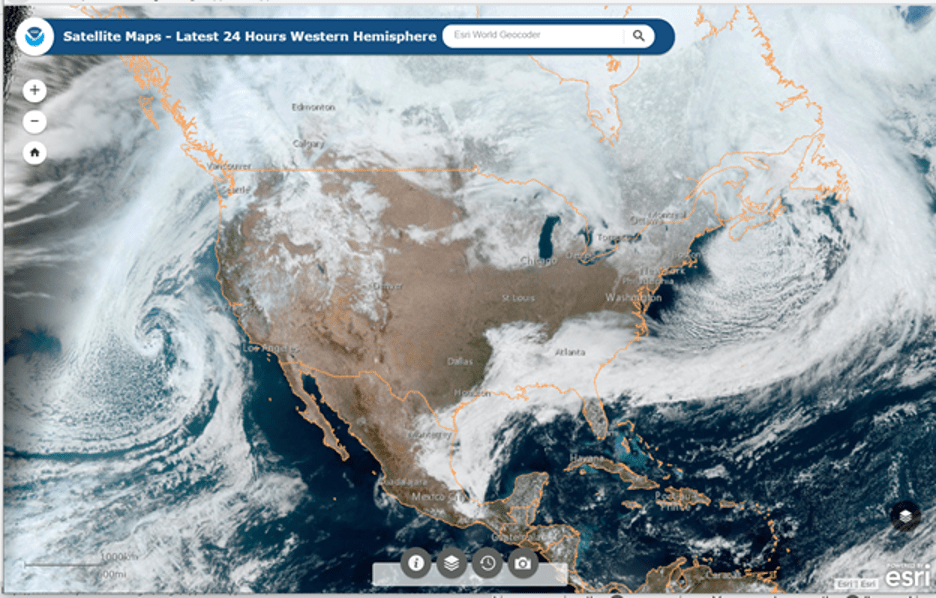
Figure 1: Visible Satellite Imagery (NOAA) 15z March 3rd, 2021
To further explore the strength of the system, we can look to the infrared satellite image shown in Figure 2. On an infrared satellite image, the clouds that are higher in the atmosphere and therefore colder appear brighter white, while the clouds that are closer to the ground and warmer appear darker gray. As you can see in Figure 2, there is not a great contrast of color between the low-pressure system we are analyzing and the ocean, meaning the clouds are lower to the ground and warmer than we would usually expect out of a low-pressure system. Since the clouds do not reach as far up into the atmosphere, that indicates that there is little to no convective activity that would produce events such as severe thunderstorms.
 Figure 2. Infrared Satellite Imagery (UW Madison) 15Z March 3rd, 2021
Since the biggest impact of this low-pressure system to the human population was the precipitation aspect, we can turn to the radar reflectivity image as shown in Figure 3 to help decipher the intensity and type of precipitation that was expected from this storm. Although the radar does not specifically distinguish rain from snow, there are a few ways you can better tell them apart. Areas with cooler colors and a smoother appearance indicate a snow or mixed precipitation event while warmer colors and a more defined appearance indicate rainfall. In Figure 3, which displays the low-pressure system hitting the California coast, you can see there are some areas of more intense rainfall indicated by the yellow and small pockets of orange. However, if you look to the Northern portion of the system, the signature appears blue and smoother in nature indicating that the precipitation was falling as snow in the mountains of Southern California. Another feature on radar to note is all the dispersed blue areas shown sporadically across other states. These could easily be mistaken for signatures of precipitation; however, they are most likely false echoes being returned to the radar from buildings, landforms, or even large groups of insects or birds.
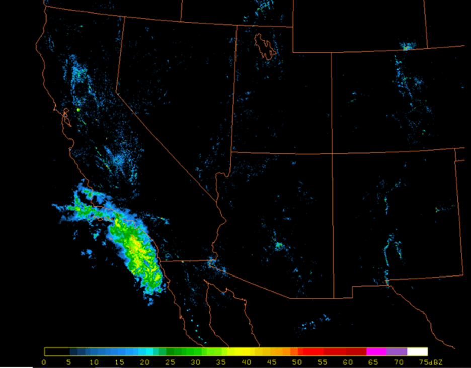
Figure 3. NEXRAD Radar Reflectivity Imagery 18Z March 3rd, 2021
The strength of a low-pressure system can also be analyzed by going up much higher in the atmosphere, around 250 mb, and looking at how it is supported by upper atmosphere winds and the jet stream. As shown in Figure 4, the jet stream is indicated by the colors with blue being slower wind speeds and the darker pink being faster wind speeds. The pockets of the darker pink color are known as jet streaks which are known for their very fast winds and supporting stronger systems. Looking off the coast of California, it is clear that the low-pressure system is supported by a trough and upper-level winds, but not by any major jet streak. This matches up with the conclusion we came to previously that this low-pressure system was of a weaker nature. Another interesting phenomenon to note on this map is the split flow of the jet stream across the continental United States. There are two major jets that interact across the United States, the polar jet and the subtropical jet, and you can clearly see the two split off from each other and then join back together off the East Coast.

Figure 4. 250 hPa Jet Stream (Alicia Bentley) 12z March 3rd, 2021
Ultimately this low-pressure system, while well-defined in shape, was overall a fairly weak system. However, it was impactful in the sense that it brought much-needed precipitation to Southern California, about 1/10th of an inch to be exact. Once the system dropped its precipitation, it quickly dissipated and broke apart as it moved inland over the Rocky Mountains, limiting the impact it would have on the rest of the country.