A Spatial Social Network (SSN) is a type of network where nodes and edges have a defined geographic location (i.e., they are geolocated) and edges specify relationships between individuals or organizations.
Edges in a spatial social network may represent personal or organizational relationships between family members, business partners, members of the same interest group, local governments, etc. Although networks of international imports and exports or where people travel for vacation are spatial networks, they are not consider spatial social networks because they don’t represent personal or organizational relationships.
In a spatial social network, distance between nodes can be measured as network distance or geographic distance.

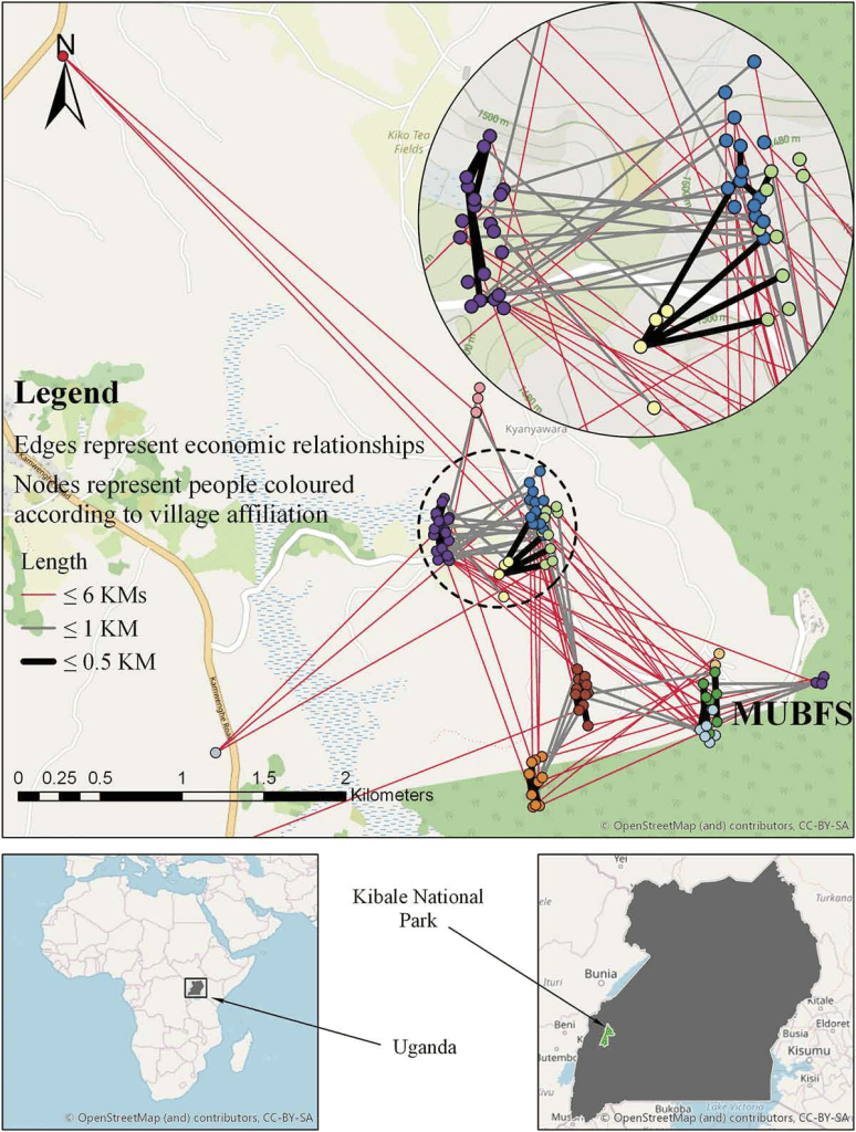
A geolocated social network of households in the Amazon where edges represent hosting one another at the home (courtesy of Paul Hooper) is divided into three modules. The households are then mapped atop a spatial image of the study area to show that nearer households tend to be in the same modules (from Andris, 2016).
Further Reading:
In this entry from the Geographic Information Science & Technology Body of Knowledge, Andris (2019) introduces the concept of a social network (SN), describes their spatial properties, and explains how to embed them into GIS.
In this chapter from the Handbook of Spatial Analysis in the Social Science, Andris & Sarkar provide further explanation of SSNs and their applications in research.
In this journal article in Computational Urban Science, Wu et al. (2022) conducted a bibliometric analysis to gain insights into the research landscape of spatial social network analysis.
In this entry from the Encyclopedia of Social Network Analysis and Mining, Gunturi et al. (2017) model spatiotemporal networks, which are described as network representation of social relations among actors who are oriented in geographical locations over time.
In this conference paper from the Annual International Conference on Geographic Information Science, Sarkar et al. (2017) discuss the challenges and possibilities of combining of spatial and social network concepts.
SSN Visualizations:
Take a look at these visualizations of Spatial Social Networks! Click on the images below to view each paper and learn more.

Redrawing the map of Great Britain from a network of human interactions
Ratti C., Sobolevsky S., Calabrese F., Andris C., Reades J., Martino M, et al. 2010. PLoS ONE 5(12): e14248.
To racketeer among neighbors: spatial features of criminal collaboration in the American Mafia
Andris, Clio, DellaPosta, Daniel, Freelin, Brittany F., Zhu, Xi, HInger, Bradley and Chen, Hanzhou. 2021. International Journal of Geographic Information Science. 35(12), pp.2463-2488.
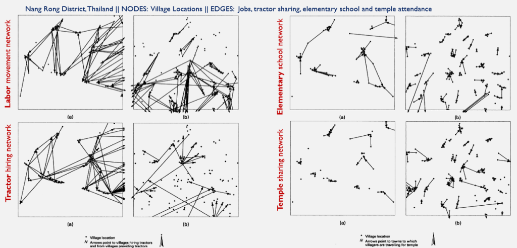
Spatial arrangement of social and economic networks among villages in Nang Rong District, Thailand
Faust, K., Entwisle, B., Rindfuss, R.R., Walsh, S.J. and Sawangdee, Y. 2000. Social Networks, 21(4), pp.311-337.
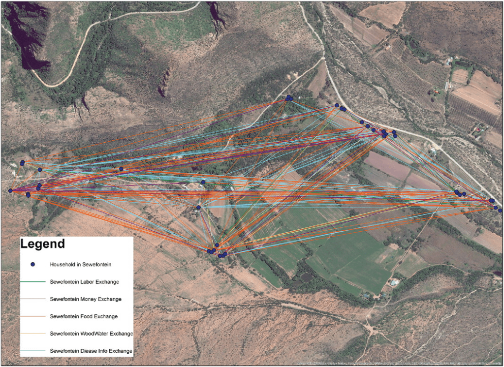
Spatial social network analysis of resource access in rural South Africa
Schramski, S. and Huang, Z. 2016. The Professional Geographer, 68(2), pp. 281-298.
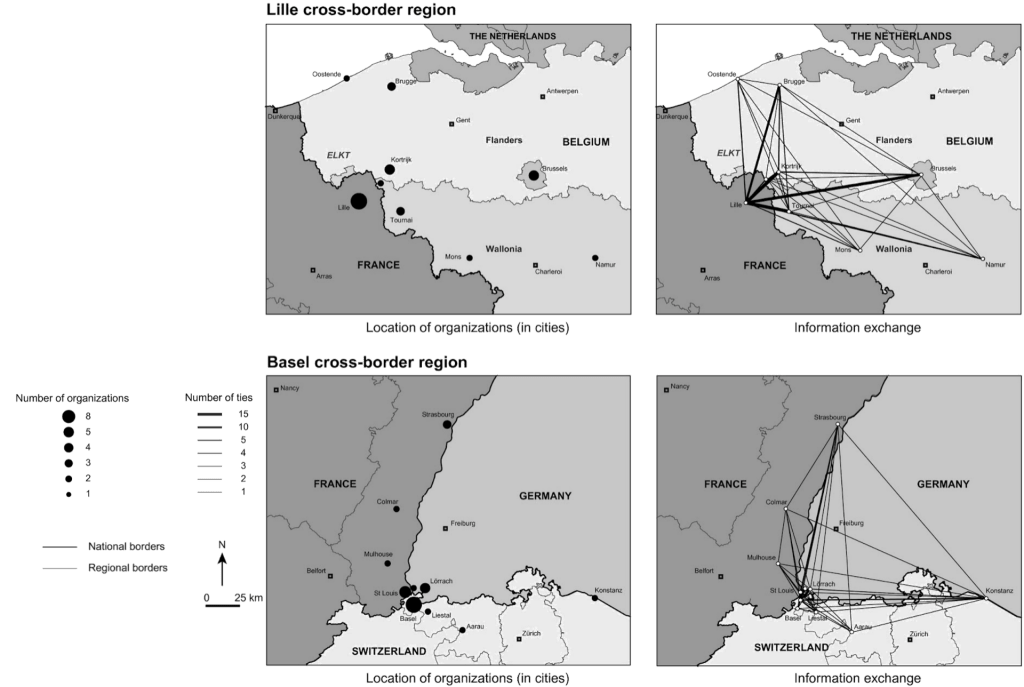
Borders moderating distance: a social network analysis of spatial effects on policy interaction
Sohn, C., Christopoulos, D. and Koskinen, J. 2020. Geographical Analysis, 52(3), pp.428-451.
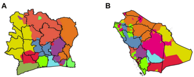
Delineating geographical regions with networks of human interactions in an extensive set of countries
Sobolevsky S, Szell M, Campari R, Couronné T, Smoreda Z and Ratti C. 2013. PLoS ONE, 8(12), e81707.
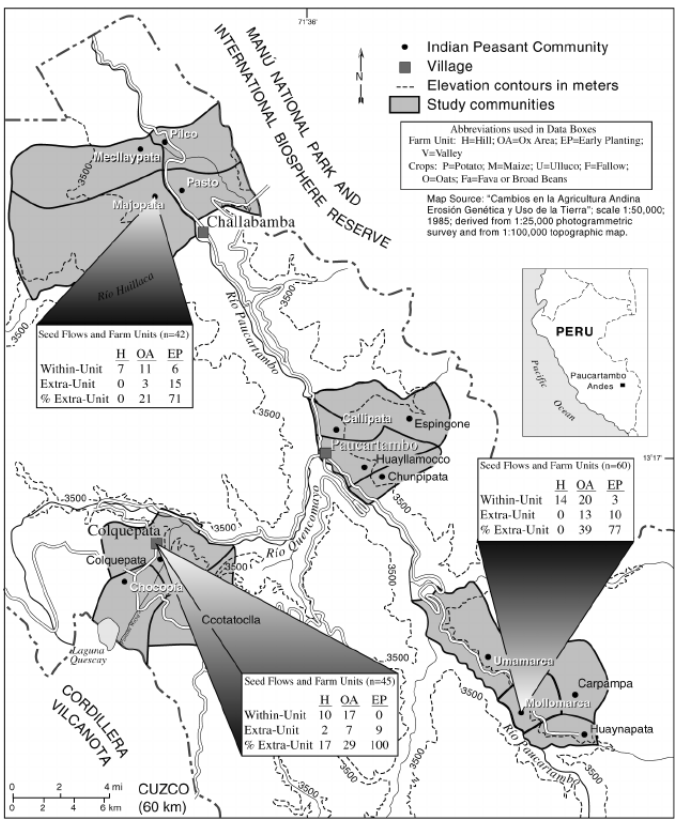
Geographies of seed networks for food plants (potato, ulluco) and approaches to agrobiodiversity conservation in the Andean countries
Zimmerer, Karl. 2003. Society and Natural Resources, 16(7), pp.583-601.
Integration of spatial and social network analysis in disease transmission studies
Emch, Michael, Root, Elisabeth D., Giebultowicz, Sophia, Ali, Mohammad, Perez-Heydrich, Carolina, and Yunus, Mohammad. 2012. Annals of the Association of American Geographers, 102(5), pp.1004-1015.
Neighborhood co-offending networks, structural embeddedness, and violent crime in Chicago
Bastomski, Sarah, Brazil, Noli and Papachristos, Andrew V. 2017. Social Networks, 51, pp.23-39.

Regions and borders of mobile telephony in Belgium and in the Brussels metropolitan zone
Blondel, Vincent, Krings, Gautier and Thomas, Isabelle. 2010. Brussels Studies.
Network closure and integration in the mid-20th century American mafia
DellaPosta, Daniel. 2017. Social Networks. 51, pp.148-157.
Metrics for characterizing network structure and node importance in Spatial Social Networks
Sarkar, Dipto, Andris, Clio, Chapman, Colin A. and Sengupta, Raja. 2018. International Journal of Geographic Information Science. 33(5), pp.1017-1039.
Challenges for social flows
Andris, Clio, Liu, Xi, Ferreira, Joseph. 2018. Computers, Environment and Urban Systems. 70, pp.197-207.
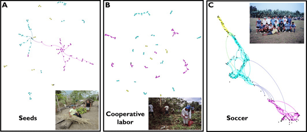
Rural social networks along Amazonian Rivers: Seeds, labor and soccer among communities on the Napo River, Peru
Abizaid, C., Coomes, O.T., Takasaki, Y. and Arroyo-Mora, J.P. 2018. Geographical Review, 108(1), pp.92-119.
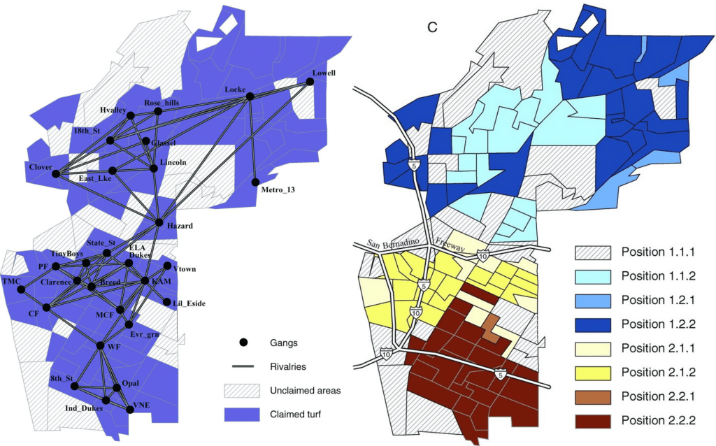
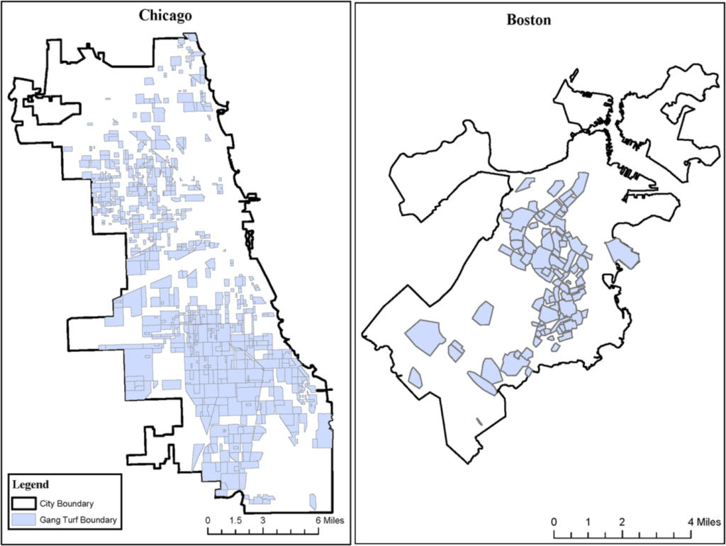
Spatializing social networks: Using social network analysis to investigate geographies of gang rivalry, territoriality, and violence in Los Angeles
Radil, S.M., Flint, C. and Tita, G.E., 2010. Annals of the Association of American Geographers, 100(2), pp.307-326.
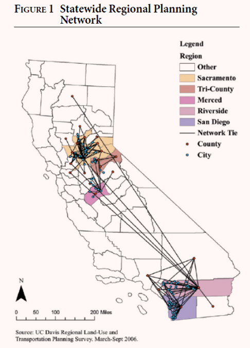
Political homophily and collaboration in regional planning networks
Gerber, Elisabeth R., Douglas Henry, Adam, and Lubell, Mark. 2013. American Journal of Political Science, 57(3) pp.598-610.
Geographic routing in social networks
Liben-Nowell, David, Novak, Jasmine, Kumar, Ravi, Raghavan, Prabhakar and Tomkins, Andrew. 2005. Proceedings of the National Academy of Sciences. 2005. 102, pp.11623-11628.
Identification of networks of sexually transmitted infection: a molecular, geographic, and social network analysis
Wylie, John L., Cabral, Teresa and Jolly, Ann M. 2005. The Journal of Infectious Diseases. 191:6, pp.899-906.
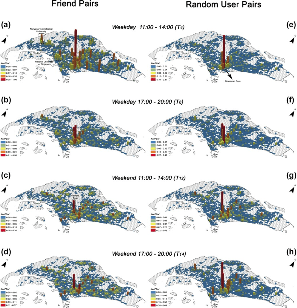
How friends share urban space: An exploratory spatiotemporal analysis using mobile phone data
Xu, Yang, Belyi, Alexander, Bojic, Iva and Ratti, Carlo. 2017. Transactions in GIS. 21(3), pp.468-487.
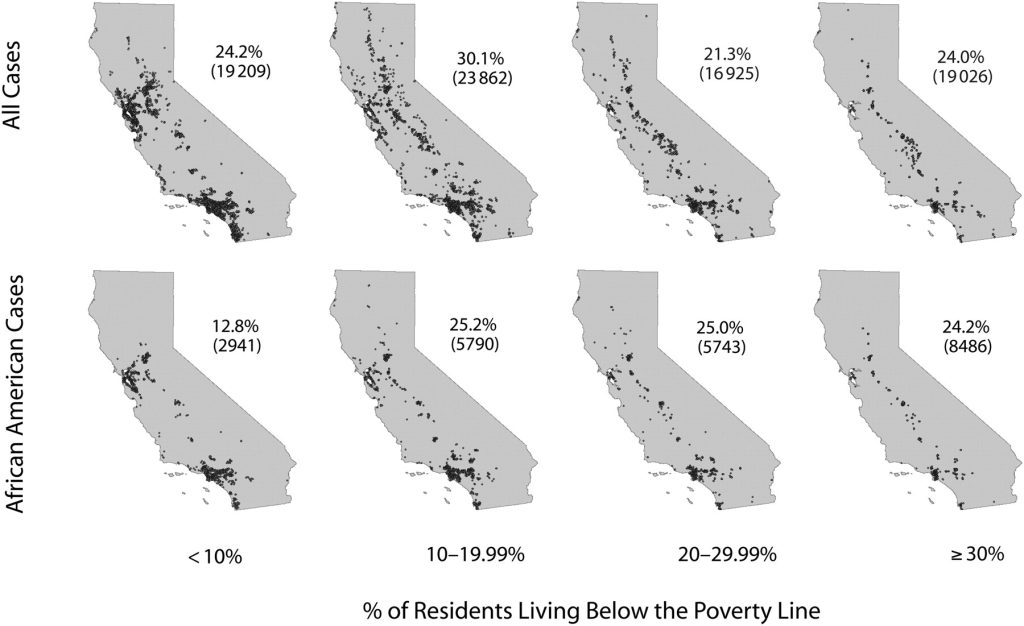
Socioeconomic gradients in sexually transmitted diseases: a geographic information system–based analysis of poverty, race/ethnicity, and gonorrhea rates in California, 2004–2006
Springer, Yuri, Samuel, Michael C. and Bolan, Gail. 2010. American Journal of Public Health. 10(6), pp.1060-1067.
The corner and the crew: the influence of geography and social networks on gang violence
Papachristos, Andrew, V., Hureau, David M. and Braga, Anthony, A. 2013. American Sociological Review. 78(3), pp.417-447.

Social network analysis of nonprofits in disaster response: the case of Twitter during the COVID-19 pandemic in the United States
Gong, X., Peng, S., Lu, Y., Wang, S., Huang, X., and Ye, X. 2022. Social Science Computer Review, 0(0).

