Just 11 days after the Moore, Oklahoma tornado left 25 dead, 7 of them elementary school children, the Oklahoma City metro area held its breath a second time this month, particularly those around the small town of El Reno. The record-breaking 2.6 mile wide “El Reno Tornado” ensued, veering through mostly unpopulated areas, yet killing 8 people: how did this happen?
The Right Fuel For This Storm
Three air masses came together to fuel this dangerous tornado-producing storm. Cold arctic air from Canada in the north and northwest, dry air from the west and southwest, and warm, moist, and unstable air from the Gulf of Mexico all converged in the state of Oklahoma. The cold air advection via a cold front had stalled, indicated by the stationary front seen in Figure 1. The warm and cool air meeting had nowhere to move horizontally, so the warm air overtook the denser cooler air and rose as day-time heating at the surface occurred.

Figure 1. Surface Analysis of Oklahoma at 0900 UTC (4 a.m. CDT) on May 31, 2013, from WPC Severe Weather Archive Page
A Storm Is Born
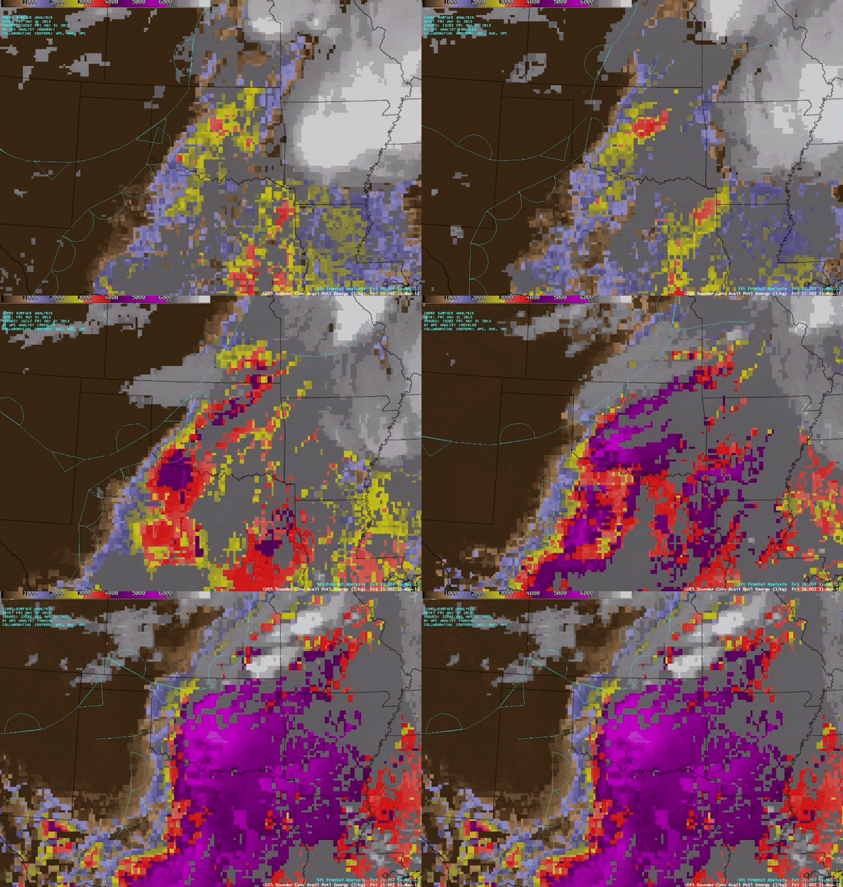
Indicated in Figure 2, surface CAPE (Convective Available Potential Energy) values soaring over 5000 J/kg extended over much of the state of Oklahoma east of the dry line, or front of dry air. The deep purples and reds indicate this instability, with more orange colors representing drier and stable air, mainly west of the dry line. In short, there were mass amounts of instability and potential for severe thunderstorms, tornadic activity, and large hail to occur.

Figure 2. CAPE Values from 1200-2200 UTC (7 a.m. – 5 p.m. CDT), from WPC Analysis Fanning
By 4 p.m., the CIN (Convective Inhibition), the “capping mechanism” preventing the increasing hot air at the surface to rise, finally gave way, resulting in the extremely warm air rising very quickly, producing convective thunderstorms as seen in visible satellite imagery in Figure 3. The wrinkle-like characteristics of these cloud tops indicate rising air hitting the tropopause, creating overshooting cloud tops of cumulonimbus clouds. As time progresses, these thunderstorms grow over much of eastern Oklahoma, not traveling much due to the stationary front parked over the state, further fueling these storms and unleashing mass amounts of rain.
Figure 3. Visible Satellite Imagery from 2100 UTC – 0100 UTC (4 – 8 p.m. CDT), from GOES-14 0.63 micrometer channel
Rush Hour Becomes Rushing For Cover
Conditions continued to deteriorate over Oklahoma into the late afternoon and early evening hours. The convective thunderstorms continued to mature, with one supercell producing the El Reno Tornado just after 6 p.m. Side by side radar imagery from a base reflectivity radar (left) and velocity radar (right) indicate the lifespan of this tornado in Figure 4.

Figure 4. Base Reflectivity (left) and Velocity radar (right) during the El Reno Tornado’s lifespan, from https://storymaps.arcgis.com/stories/9895d535c2a247e4997fb85493428be8
The hook-shaped precipitation on the southern end of the supercell, also known as a “hook echo”, is indicative of tornadic activity. This hook is also visualized with a swirling green and red pattern in the same spot on the velocity radar, with green colors meaning wind blowing towards the radar and red indicating wind flowing away from it. The presence of red amidst green, or vice-versa, is indicative or rotating motion in the atmosphere, strongly suggestive of tornadic activity. Amidst this tornado, already congested rush hour traffic spanning several interstates was exacerbated by false messaging from local meteorologist Mike Morgan, who erroneously suggested to the public to drive south away from the storm. He has since apologized for these statements. Rather than trying to outrun a tornado, meteorologist and now professor at Ohio University Jana Houser gives insight into what her family does in the event of a tornado: “Our safe place is in the central bathroom in the bathtub with a mattress placed over us to protect from falling or flying debris.”
8 Dead, Including 3 Storm Chasers, From Historic Tornado
The tornado dissipated prior to interacting with populated subdivisions sprawling the outskirts of Oklahoma City, but many people were caught off guard. Heavier than usual rain shielded the tornado from view, making it difficult for storm chasers and drivers alike to see. Also, as seen in Figure 5, the 2.6 mile wide wind field of this tornado, compared to the only 0.3 mile wide condensation funnel, the visible part of the tornado, further misled people into believing they were safe from winds up to 290 mph. By the tornado’s dissipation, 8 people had lost their lives, all 8 being in their vehicles, with 3 being storm chasers: Paul Samaras, Tim Samaras, and Carl Young.

Figure 5. Condensation Funnel and Tornado Edge (span of winds) Comparison at 6:13 CDT, from https://www.skip.cc/chase/130531/ (courtesy of Skip Talbot)

