
Shortly after Hurricane Fiona had developed and devastated the northern parts of America, Hurricane Ian began developing. Fiona developed off a tropical wave that started off the coast of West Africa on September 7th. Similarly, Hurricane Ian’s origins can be traced back to a similar process. On September 14th, a tropical wave emerged that started to traverse across the Atlantic into a tropical storm as seen in the image below.

Figure 1: GOES-16 Visible (Band 2), September 24th, 2022. Early beginnings of Hurricane Ian as a tropical storm bubbling and developing in the Caribbean Sea.
Before Ian was a tropical storm, it unfolded as a mid-level ridge influenced its west-northwestward trajectory, steering clear of the Caribbean islands. Officially attaining tropical storm status 18 hours after formation, Ian positioned itself southeast of Jamaica. Lisa Bucci of the NOAA stated, “The storm continued to rapidly intensify over warm waters (30°C and higher) and in a low vertical wind shear environment as it turned northward towards Cuba.” From this point, Ian transformed into a Hurricane just off Cuba’s coast as a category 3 hurricane with 125 mph winds.

Figure 2: Illustrates the Reynolds Analysis of sea surface temperatures observed between September 23 and the 28th. The analysis incorporates both satellite and buoy data. These temperatures played a crucial role in creating optimal conditions leading to the intensification of Hurricane Ian, ultimately reaching a category 5 status.
The image above demonstrates the ideal conditions which allowed Ian to reach the strength and intensity it did. With these conditions, Ian developed into a Category 5 hurricane and struck the Fort Myers area with 161 mph winds. Ian exacted a tragic toll, claiming a minimum of 156 lives, with 66 directly attributed to the storm. The aftermath in Fort Myers was equally devastating, witnessing around 900 structures damaged and the complete destruction of the Sanibel Causeway.
After the storm, lots of discussion about the forecasting path of the storm was a cause of concern. The images below demonstrate the possible paths as Hurricane Ian continued to develop.
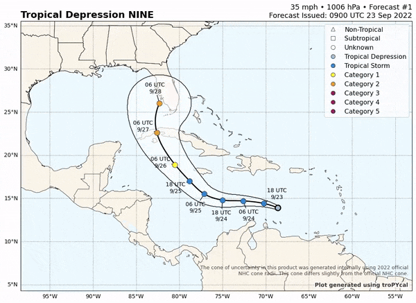
Figure 3: Forecasting paths of Ian as it transformed from a Tropical depression into a Hurricane.
NOAA stated their “forecasts revealed the cross-track error to be the largest source of error with a consistent westward bias noted.” These forecasting errors significantly strengthen the point of the use of satellite imagery, surface analysis, and upper air analysis maps when determining the development of a storm. Seth Borenstein of the AP stated “Much of the forecasting variation seems to be rooted in cool Canadian air that had weakened a batch of sunny weather over the East Coast. That weakening would allow Ian to turn eastward to Southwest Florida instead of north and west to the Panhandle hundreds of miles away”.
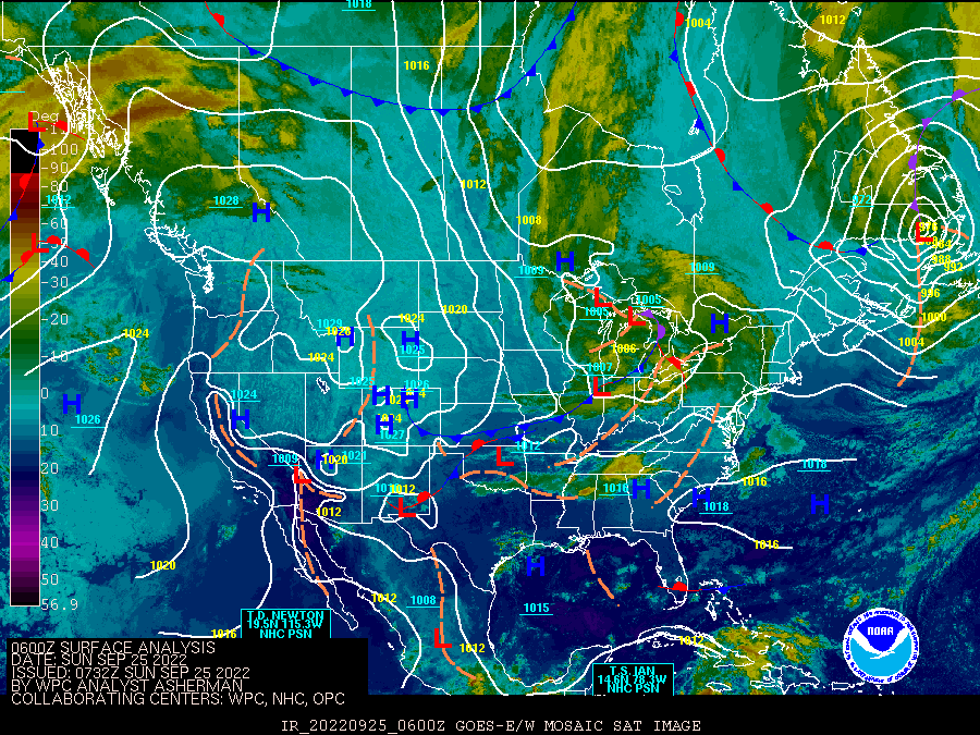
Figure 4: Collection of surface analysis maps with Satellite starting from September 25 to the 29th. Shows a cold from moving across America interacting with Ian.
In the collection of images above this Canadian air can be seen from the cold front moving across North America. Ian was originally forecasted to be up the coast of Florida, but the cold front pushed Ian across Florida.
Sources:
https://satlib.cira.colostate.edu/event/hurricane-ian/