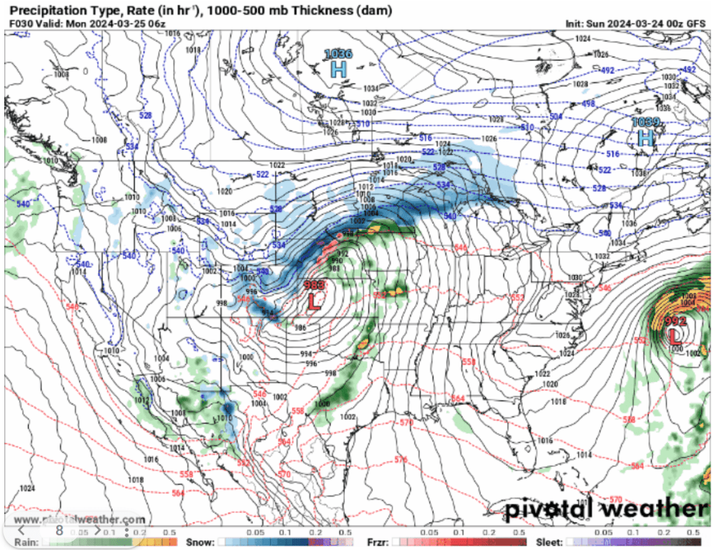
Between Sunday, March 24th, and Tuesday, March 26th a major winter storm impacted the Great Plains and upper Midwest region. Fueled by strong upper-level trough ridge dynamics, a 991 mb low formed over Kansas which not only influenced blizzard conditions to the north over the Dakotas and Minnesota, but also caused some severe weather in the southern great plains. An upper-level trough over the Rockies with an embedded jet streak (region of higher wind speeds) enhanced upward vertical motion over the central great plains. This upward vertical motion allowed the surface low-pressure system to strengthen and continue to support precipitation impacts in both the warm sector to the southeast and the cold region to the north.

March 25 0006 Z GFS 300mb heights in dam (black contours) and winds in kt (barbs, and fill pattern), accessed from pivotalweather.com

March 25 0006 Z GFS Precipitation type and rate (green rain, blue snow, pink mixed precipitation), thickness in dam (red (above freezing) and blue (below freezing) dashed contours) and sea level pressure in hPa (black contours), accessed from pivotalweather.com
To the north of the storm, there was ample stratiform precipitation in the form of snow from Nebraska through Minnesota. The highest snow totals were found in Minnesota where the most widespread precipitation was found. There are signatures of this widespread precipitation in the IR cloud top satellite image provided below. The brighter green colors indicate higher and colder cloud tops, which is a sign of heavier precipitation. Despite there being less snow over Nebraska and South Dakota, those are the regions that experienced blizzard conditions. This is due to their closer proximity to the surface low-pressure system to the south. The closer a location is to the core of a midlatitude storm, the faster winds they will experience. For an area to be experiencing true blizzard conditions there must be three hours of blowing or falling snow, winds surpassing 35 mph, and sub quarter mile visibility.

Infrared Satellite Image Goes-16 Cloud Tops Band 11 Accessed from the CIRA RAMMB Slider

Key upper midwest impacts highlighting the snowfall, the winds, and the region of blizzard conditions in Nebraska and South Dakota. Accessed from NOAA Weather Prediction Center
To the south of the low-pressure system, there were some minor severe weather impacts. In particular, there was a series of EF-1 tornadoes within the vicinity of Garden City Kansas. The tornado shown in the figures below was identified on radar imagery and through a damage survey following the storm. A tornado can be identified through Doppler radar’s radial velocity feature. The Doppler effect that makes train whistles or fast cars sound different as they pass by, also allows us to see what direction the wind is moving relative to the radar site. In most cases, seeing a couplet of wind moving towards and away from the radar site, like in the figure below, indicates rotation at the surface and a potential tornado.

Radial Velocity over Garden City Kansas during the tornado, red away from the radar, yellow towards the radar. Accessed from the NOAA NSSL MRMS

Tornado report in Garden City Kansas from the NOAA NWS Storm Prediction Center Storm Reports

