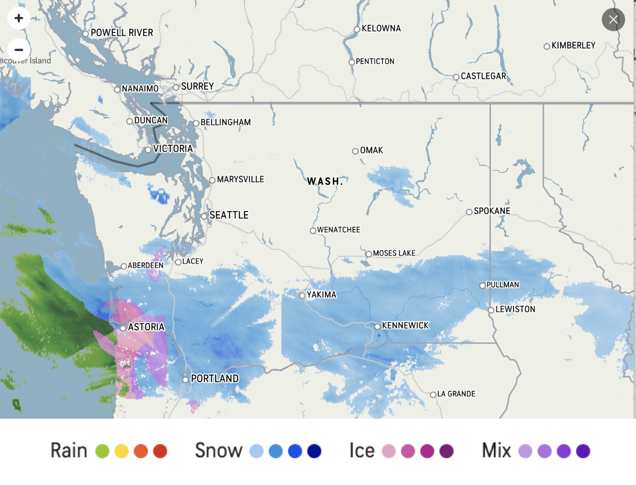
Washington and other areas of the Northwest started receiving snowfall on Thursday, February 11th in the evening and continued to receive snowfall into the subsequent weekend. The highest amounts the area was predicted by the local NWS branch was around one foot around in the Cascades of Pierce and Lewis Counties. Closer to the coast, the area received a mixture of snow, sleet, and freezing rain, as shown by the radar taken from accuweather at 17Z on Friday February 12th. As of Saturday, February 13th at 18Z, a majority of the state of Washington still had light to moderate snowfall. The majority of Washington and Oregon as of 18Z on Saturday February 13th in either a winter storm warning or a winter weather advisory.
 Figure 1: Accuweather Radar screengrab taken at 17Z on Friday, February 12th. This radar shows snow in parts of Washington and Northern Oregon and a combination of snow and ice on the coast.
There was a low-pressure system off of the coast of the northwest that caused this snowfall upon its arrival to the states. As of 15Z on Friday February 12th the mean sea level pressure of center of the low was 1007 millibars, the ‘L’ seen directly off of the Oregon coast on the WPC surface level analysis map. As displayed on the water vapor image taken at 15Z on Friday February 12th. the frontal boundary caused by the low has very high and cold cloud tops, the frontal boundary was also followed by a region of dry air, typical of a cold front like this. There was another low that followed the first that was responsible for bringing the second round of snow to the Washington and Northern Oregon coast. At the center, this low has a mean sea level pressure of 990 millibars as of 15Z on Friday, February 12th, as shown by the same WPC surface level analysis.
 Figure 2: GOES 17 water vapor image taken at 15:50:32Z. Shows frontal boundary in addition to an area of cyclonic motion associated with the second low off of the Canadian coast.
 Figure 3: WPC Surface Analysis taken at 15Z on Friday, February 12th. This surface map shows both the 1007 millibar low off of the Oregon coast and the 990 millibar low off of the Canadian coast.
This second low the area saw was formed in exact accordance with the Norwegian Cyclone model with an occluded front sourcing from the center, a cold front branching off to the west of the occluded front and a warm front branching to the east of the occluded front. This is indicative of an extratropical cyclone being in the mature stage meaning the low is at its maximum strength and that the cyclone will begin to slow down in movement, which is what happened. The result of these lows was Washington and Oregon receiving snow that ranged from traces up to 18 inches according to the National Weather Service. The snow continued to fall and caused snow as far East as Wyoming and Colorado.

