

Arabi Tornado moves through the Lower Ninth Ward Credit: WDSU New Orleans
With the advent of Spring, tornado season has officially begun, as evidenced by the March 21-23 Tornado Outbreak, in which 76 tornadoes were confirmed across the South and Eastern United States. As the extratropical cyclone in Figure 1 made its way east, it brought 2 tornadoes to New Orleans, an EF1 in Mandeville/Lacombe and an EF3 in Arabi. While the Lacombe EF1 was within the moderate risk area highlighted by the Storm Prediction Center March 22nd Day 1 Convective Outlook, the Arabi EF3 developed outside of the moderate risk area and caught many by surprise. To better understand the formation of what has been determined the strongest tornado on record to hit New Orleans, we will look at some of the dynamics at play.

Figure 1 – GOES Mid-level Water Vapor Imagery – March 23, 2022 00:01 UTC (19:01 CST)
In Figure 1, we can see the squall line of the extratropical cyclone moving over Louisiana. We can also see the “X” (mid-to-upper level vorticity maxima) is west of the low-pressure system, indicating that this cyclone structure is westward-tilt with height. This indicates that there is positive differential vorticity advection and the system will likely strengthen over time. We can also identify the katafront, indicated by the cold front location west of the deformation zone (the strong brightness temperature gradient and shearing out of the white). This indicates that the storms will pass before the cold front passes and can indicate a drop in humidity at the surface, as the dry air ahead of the katafront moves through. However, from the KLIX sounding and the jet stream analysis, we can see that the flow of moisture from the Gulf of Mexico, aided by the jet stream, kept the humidity at the surface high. However, we do notice a humidity drop around 800-750mb in the KLIX sounding. We can also compare the jet stream image to the strong brightness temperature gradient in Figure 2 to identify the jet streak over the same area, which helps aid in upper-level wind shear, divergence, and venting of the storm to increase vertical development.

Figure 2 – 850 mb height/temperature/dewpoint – March 23, 2022 00Z (7pm CST March 22, 2022)
In the 850 mb height/temp/dwpt, we can see the flow of moisture from the Gulf of Mexico bringing the moisture into the NOLA area, a vital ingredient to mesocyclone and tornado formation. We can also identify a potential low level jet (as indicated by the 45kt wind barbs) aiding in the transport of this moisture. This warm, moist air at the surface rises as the cool/dry cold front air forces the warmer/moist air up, which creates instability and leads to vertical development. This drives our lift component of the mesocyclone formation. All the discussed ingredients: shear, lift, instability, and moisture aid in the formation of tornadic cells. These, in addition to the significant CAPE observed on the KLIX sounding suggest that New Orleans was ripe for tornadic activity on March 22, 2022. Just before 7:00pm CST on March 22nd (00Z March 23), a tornado watch was issued for New Orleans and for the Lacombe/Mandeville area. By 7:21pm, the Arabi EF3 tornado was confirmed.

Figure 3 – RadarOmega Composite of Arabi EF3 – March 23, 2022 7:20p
Top Left: Reflectivity Top Right: Velocity Bottom Left: Correlation Coefficient Bottom Right: Spectrum Width Signature
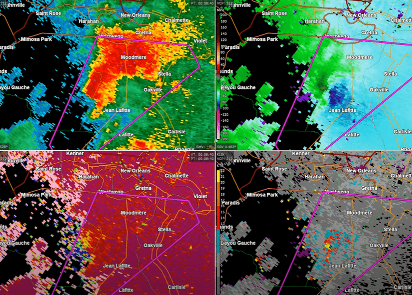
Figure 4 – KLIX RadarOmega Composite of Arabi EF3 – March 23, 2022 7:30p
Top Left: Reflectivity Top Right: Velocity Bottom Left: Correlation Coefficient Bottom Right: Spectrum Width Signature
The EF3 tornado can been identified on the above KLIX radar composites from just prior to confirmation (Figure 3) and during the tornado track (Figure 4). Some possible reasons why this tornado seemed to catch meteorologists by surprise was due to it being outside out the moderate risk area, as well as the fact that the supercell on the reflectivity did not look quite as impressive as the Lacombe EF1 , which was the picture-perfect supercell (note the impressive hook echo in the link). However, on the reflectivity we can still identify a strong forward-flank downdraft, rear-flank downdraft, inflow notch, and hook echo. As evidenced in Figures 3 and 4, we can see the rotational couplet in the velocity composite tightening/developing significantly as the Arabi tornado moved through the Lower Ninth Ward. We can also make out a bit of a correlation coefficient drop to the left of Jean Lafitte, indicating that there is likely debris of various sizes being thrown around by the tornado. On the spectrum width signature, we can see an area of varying velocities synonymous with objects being flung around by the tornado. The National Weather Service declared the Arabi tornado an EF3, with significant damage and winds up to 160 mph. This broke the past record of the EF3 that struck north of Arabi in 2017 with winds of up to 150 mph. Overall, the tornado tracked 11.5 miles and caused significant damage to the Lower Ninth Ward, including one death and two significant injuries.