Astronomically speaking, the beginning of the spring is defined by the spring equinox. This year, the equinox occurs in a few days: on March 19, 2024. And as people prepare to receive the spring weather, the Southeast has been receiving a decent amount of rain almost once a week. Last weekend (March 8, 2024, to March 9, 2024), a storm system developed and caused flash flood alerts all across the Southeast, from the southeastern part of Texas to South and Central Georgia. The total precipitation forecast for Georgia, as shown in Figure 1, estimated up to 5 inches of rain in some areas.

Figure 1. Forecast of rain totals in the Southeast from Friday, March 8, 2024 through Saturday, March 9, 2024. Source: FOX Weather.
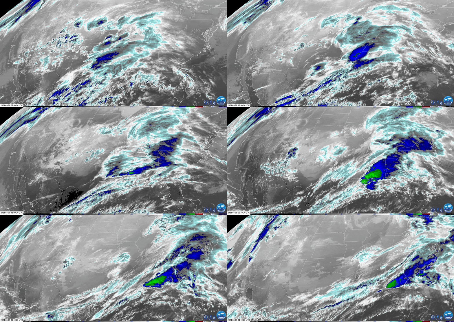
By looking at the infrared (IR) satellite imagery from Figure 2 we can get more information about the storm development process. The darker blue and green colors in the image represent colder temperatures, meaning that the cloud tops extend to higher altitudes – a clear indicator of stronger storm activity. As observed, the higher cloud tops are first covering the southeastern region of Texas on March 8 at 2:00 UTC, and then displace towards the East until they develop into even higher clouds as observed on the darker blue and green colors covering the south Alabama region and Georgia on March 9, 2024, at 10:00 UTC. We can also observe how the cloud system extends basically to the entire East Coast, from Georgia all the way up to New York.

Figure 2. Infrared image loop showcasing the storm system development from Friday, March 8, 2024, 02:00 UTC through Saturday, March 9, 2024, 14:00 UTC. Source: RAMMB of NOAA/NESDIS.
Another way of getting more information about precipitation is by looking at the radar reflectivity measurements from Figure 3. The areas with higher values of reflectivity (dBZ) correspond to stronger precipitation activity and are depicted by warmer color tones (yellow, orange, and red). As seen, the thunderstorm activity progressed from Texas and Louisiana to Alabama and Georgia and then advanced toward the Northeast.

Figure 3. Composite reflectivity radar imagery from Friday, March 8, 2024, 08:24 UTC through Saturday, March 9, 2024, 19:24 UTC. Higher values of reflectivity (dBZ) are associated with more intense precipitation. Source: Multi-Radar Multi-Sensor, NSSL-NOAA.
Storm activity is typically associated with the formation of low-pressure points. These are characterized by strong convection activity, which is the process of transporting warm and moist air vertically in the atmosphere, ultimately resulting in cloud formation and storm development in this case. This phenomenon can be visualized by the surface analysis maps from Figure 4. Two low-pressure points were located in southern Alabama and Mississippi when the strongest precipitation activity was occurring over Alabama and Georgia (left image in Fig. 4).

Figure 4. Surface analysis maps issued on Saturday, March 9, 2024, 03:00 UTC (left) and Sunday, March 10, 2024, 00:00 UTC (right). Source: WPC, NOAA.
As time passed by, the low-pressure points moved northeast to West Virginia and Maryland, causing the overall storm system to move accordingly (right image in Fig. 4). We can also observe that the movement of the convective system was caused by the progression of the cold fronts – denoted by the blue lines with triangle markers – headed towards the East, clearing the skies on the Southeast.
Finally, the initial forecast prediction for the total amount of rain can be verified utilizing radar imagery. For instance, Figure 5 shows the measured precipitation amount over a 12-hour period on Saturday, March 9 at 12:00 UTC, when the storm system was leaving Georgia. Southern Alabama and Georgia received a large amount of precipitation, estimated at around 5 inches of rain, which is very similar to the initial prediction shown in Figure 1.

Figure 5. Radar estimation for accumulated precipitation over the last 12 hours corresponding to March 9, 2024, at 12:00 UTC. Source: Multi-Radar Multi-Sensor, NSSL-NOAA.
Nothing is certain about the weather, so we will see how many more thunderstorm systems develop as Georgia residents prepare to welcome the Spring and the warmer days.

