
 Figure 1: GOES-16 True Color RGB on 9 April 2021 from 1230 UTC to 2130 UTC, in 10 minute intervals. Source: University of Wisconsin-Madison Space Science and Engineering Center (SSEC).
For the first time since 1979, the La Soufriere volcano in the eastern Caribbean has erupted, sending large plumes of volcanic ash and dust eastward into the Atlantic Ocean. According to seismic research conducted by the University of the West Indies, this active stratovolcano in the island country of Saint Vincent and the Grenadines has only had five explosive eruptions since 1718. Although a series of smaller eruptions began in December 2020, the most recent explosive eruptions began on 9 April 2021, and continued through at least 13 April 2021.
 Figure 2: GOES-16 Ash RGB on 10 April 2021 from 1045 UTC to 1415 UTC, in five minute intervals. Source: University of Wisconsin-Madison Space Science and Engineering Center (SSEC).
Through many recent advances in satellite detection, GOES-16 satellites are able to use multiple frequency bands through various forms of RGB (red, green, blue) imagery to detect key meteorological and geological features, including volcanoes. Since volcanoes are capable of producing ash and sulfur dioxide gas that can be hazardous to public health and aviation, the GOES-16 Ash RGB product can be useful for understanding where such plumes are headed. Figure 2 shows the Ash RGB loop on the morning of 10 April 2021, which features frequent explosive eruptions from La Soufriere. At higher altitudes, the brown color represents high, thick ice clouds, whereas the tans and dark yellows indicate ash mixed with sulfur dioxide. Likewise, pure ash is shown in red and magenta, and is often at lower altitudes than the volcanic plume as it settles onto the surface beneath.
 Figure 3: Absorbing Aerosol Index (AAI) measured by GOME-2 onboard the MetOp (Meteorological Operational) satellites from 9-13 April 2021. Source: EUMETSAT Satellite Application Facility on Atmospheric Composition (AC SAF).
Through the frequent and dense volcanic emissions between 9-13 April 2021, high concentrations of ash and sulfur dioxide were present in several islands that neighbored Saint Vincent, to include Saint Lucia to its north, the Grenadines and Grenada to its south, and Barbados to its east. Figure 3 provides another vantage point of volcanic emissions by looking at the aerosol absorbing index (AAI) measured by the European-based EUMETSAT organization, which is a measure of the absorption of ultraviolet (UV) radiation by “active” particles in the UV spectral range. As consistent with the previous satellite products, the largest initial explosions occurred on 9-10 April 2021, and is indicated by greater values of AAI above, as volcanic clouds deflect solar radiation back into space or the upper levels of the atmosphere. Barbados, which is downstream of the plume on 10 April 2021, issued a severe volcanic ash warning and temporarily closed their international airport in response to the high concentrations of ash and sulfur dioxide that were transported eastward. In the sounding below (Fig. 4), westerly winds at higher altitudes confirmed the motion of the volcanic plume as it reached the upper troposphere, and continued to serve as the dominant motion of ash and sulfur dioxide through at least 13 April 2021.
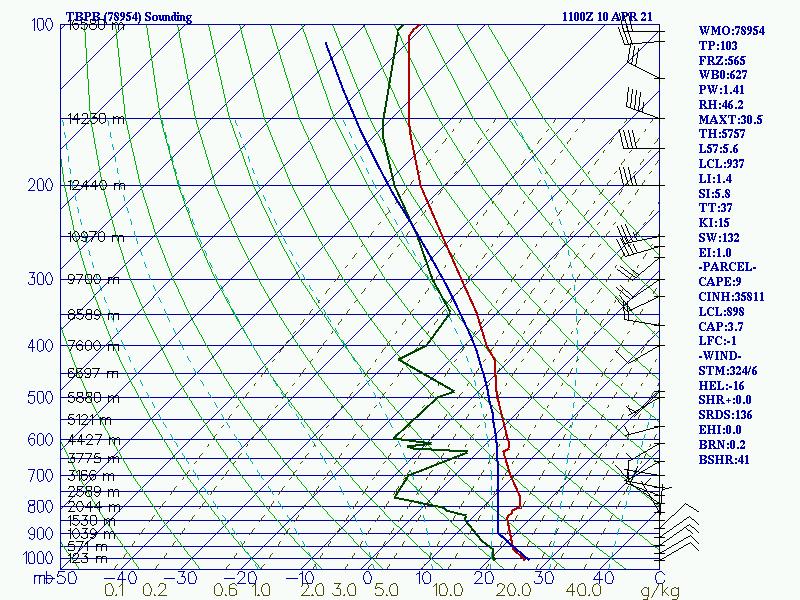 Figure 4: Sounding from Grantley Adams International Airport (TBPB) in Barbados on 10 April 2021. Wind barbs (in knots) are shown in black on the right edge of the sounding.